Unlock a world of possibilities! Login now and discover the exclusive benefits awaiting you.
- Qlik Community
- :
- All Forums
- :
- GeoAnalytics
- :
- How to use different map backgrounds?
- Subscribe to RSS Feed
- Mark Topic as New
- Mark Topic as Read
- Float this Topic for Current User
- Bookmark
- Subscribe
- Mute
- Printer Friendly Page
- Mark as New
- Bookmark
- Subscribe
- Mute
- Subscribe to RSS Feed
- Permalink
- Report Inappropriate Content
How to use different map backgrounds?
How can I change the background of the map from the default OpenStreetMap? What other options are available please? Thanks
- Mark as New
- Bookmark
- Subscribe
- Mute
- Subscribe to RSS Feed
- Permalink
- Report Inappropriate Content
Hi Callum,
Thanks for your question.
On the main map layer in the properties - there is a Base Map setting - you can change it there.

You will also note there is a link that brings you directly to the online doc.
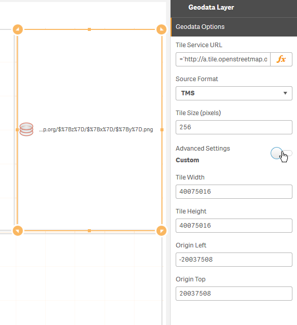
The Geodata Layer will allow you to use another tile server: (TMS, WMS, GeoJSON)

GeodataLayer - visualizes background map data, either from a tile service or from a file, such as GeoJSON. The URL is an expression that is evaluated at each selection and data is reloaded when the URL changes. This way it can connect to external data services with dynamic data.
I am attempting to get a working example for you as well.
Let me know how you do
When applicable please mark the appropriate replies as CORRECT. This will help community members and Qlik Employees know which discussions have already been addressed and have a possible known solution. Please mark threads as HELPFUL if the provided solution is helpful to the problem, but does not necessarily solve the indicated problem. You can mark multiple threads as HELPFUL if you feel additional info is useful to others.
Regards,
Michael Tarallo (@mtarallo) | Twitter
Qlik
Mike Tarallo
Qlik
- Mark as New
- Bookmark
- Subscribe
- Mute
- Subscribe to RSS Feed
- Permalink
- Report Inappropriate Content
Hi Michael
I have a need to show georeferenced polygons (actual building coordinates and rooms in that building) on a map, but I would like to have the whole base map rotated so that the front of the building (currently facing South-East) to face South. In other words, I would like to rotate the base map about 45 degrees clockwise. I know I can create other polygons, but as the polygons are actual coordinates I would prefer not doing that.
If I cannot rotate the map, I would like to know if I can use another file as a base map? I do not need the world map in this case (I am disabling all the layers on the GeoAnalytics Map anyways), so using another file which is already rotated would work. I do not have a subscription to ArcGIS or something similar so a file in DropBox would be first prize. If possible, please let me know how I can do this (I have some experience in QGIS if that helps).
Please let me know if anything is unclear.
Regards,
Mauritz
- Mark as New
- Bookmark
- Subscribe
- Mute
- Subscribe to RSS Feed
- Permalink
- Report Inappropriate Content
Hi Mauritz - I added bps - he may be able to assist.
Mike Tarallo
Qlik
- Mark as New
- Bookmark
- Subscribe
- Mute
- Subscribe to RSS Feed
- Permalink
- Report Inappropriate Content
Hi,
No, you can't move the map in QGA, you have to transform the data. If you're handy you could recalculate all geometries in Sense but it's probably easier to do it in QGIS using affine transformation. Find a background vector map, rotate the data QGIS and then load it in the QGA.
Thanks,
Patric
- Mark as New
- Bookmark
- Subscribe
- Mute
- Subscribe to RSS Feed
- Permalink
- Report Inappropriate Content
Thanks Michael and Patric, I appreciate the help.