Unlock a world of possibilities! Login now and discover the exclusive benefits awaiting you.
- Qlik Community
- :
- All Forums
- :
- GeoAnalytics
- :
- Points placed incorrectly when dimension is used i...
- Subscribe to RSS Feed
- Mark Topic as New
- Mark Topic as Read
- Float this Topic for Current User
- Bookmark
- Subscribe
- Mute
- Printer Friendly Page
- Mark as New
- Bookmark
- Subscribe
- Mute
- Subscribe to RSS Feed
- Permalink
- Report Inappropriate Content
Points placed incorrectly when dimension is used in bubble layer
Hello there,
I am a new bee to Qlik GeoAnalytics .
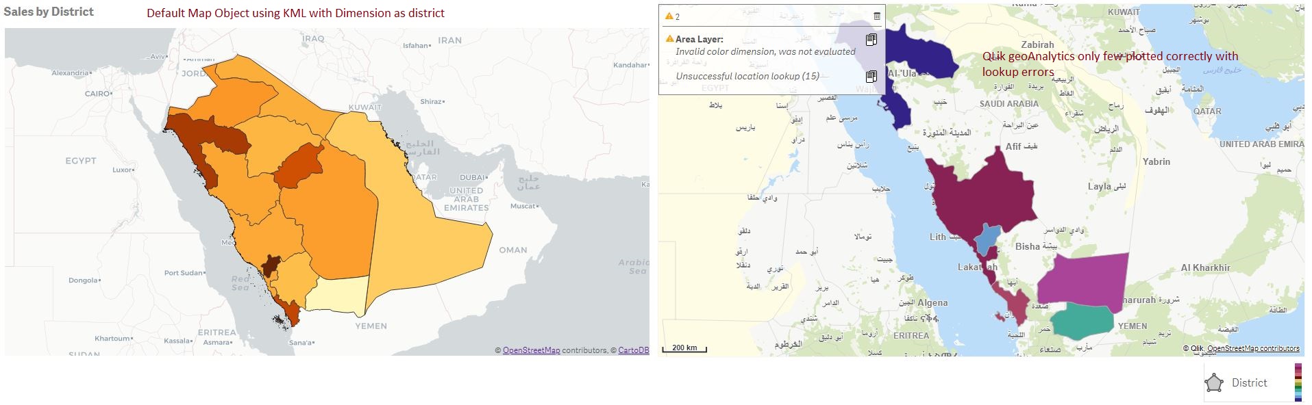
I am using Lat long to display locations on a bubble map using GeomakePoint. All the locations are plotted correctly as per co coordinates when I am using Geomakepoint as a dimension. However, if use a different dimension which are in arabic , Locations are not loaded properly and plotted elsewhere.
Same issue with the KML when we used district as a dimension.
Please advice.
Below are the screenshots and KML
- Mark as New
- Bookmark
- Subscribe
- Mute
- Subscribe to RSS Feed
- Permalink
- Report Inappropriate Content
I have investigate more on this issue,
Seems like I need to do remap.
and if the location itself does not exists with the name but only coordinates. Example on the road side, how could we alias (remap)
Could any one please suggest how to do a remap
Thanks
Mohammed Mustafa Khan
- Mark as New
- Bookmark
- Subscribe
- Mute
- Subscribe to RSS Feed
- Permalink
- Report Inappropriate Content
I used remap syntax as below but still it does not work, I am assuming we are having multiple rows of data with the same name.
"حائل": "حائــل"
Please advice
- Mark as New
- Bookmark
- Subscribe
- Mute
- Subscribe to RSS Feed
- Permalink
- Report Inappropriate Content
Hi,
In QGA location info can be provided in the dimension or in the measure "Location".
The location info can either be geometries, like points or areas or location strings, which are sent to server for lookup.
In your case, to pickup up the KML geometries: specify [Saudi District KML.Area] as the location id.
The data files didnt contain any lat long, but I recommend using something unique as the point id and make sure that the lat and long expressions evaluates. If there are several points with the same name avg(lat) works.
Thanks,
Patric
- Mark as New
- Bookmark
- Subscribe
- Mute
- Subscribe to RSS Feed
- Permalink
- Report Inappropriate Content
Thanks Patric,
I am using point dimension and area dimension for the map and for using associated name (region dimension in arabic ) in info bubble. However, If I need to add more than one dimension in info bubble i need to concatenate it, It is working ,but the dimension values are shown in single line.
I tried using new line and space using char(10) & char(13) but unfortunately it is not working.
How can we have multiple dimension values with new line for each value in info bubble.
- Mark as New
- Bookmark
- Subscribe
- Mute
- Subscribe to RSS Feed
- Permalink
- Report Inappropriate Content
Hi,
HTML tags can be used for formatting, '<BR>' make a new line.
Thanks,
Patric