Unlock a world of possibilities! Login now and discover the exclusive benefits awaiting you.
- Qlik Community
- :
- Forums
- :
- Analytics
- :
- New to Qlik Analytics
- :
- Re: Longitude and latitude to an area (KML)
- Subscribe to RSS Feed
- Mark Topic as New
- Mark Topic as Read
- Float this Topic for Current User
- Bookmark
- Subscribe
- Mute
- Printer Friendly Page
- Mark as New
- Bookmark
- Subscribe
- Mute
- Subscribe to RSS Feed
- Permalink
- Report Inappropriate Content
Longitude and latitude to an area (KML)
Hello,
I use Qlik Sense.
I have data with longitude and latitude and I want to associate these points to areas come from a KML file.
Is it possible to do that ?
Is there a function to know in witch area belong a point ?
Thank for your help
Fabrice
- Tags:
- geography
- « Previous Replies
-
- 1
- 2
- Next Replies »
- Mark as New
- Bookmark
- Subscribe
- Mute
- Subscribe to RSS Feed
- Permalink
- Report Inappropriate Content
Yes,
look at GeoMakePoint funcion.
If a post helps to resolve your issue, please accept it as a Solution.
- Mark as New
- Bookmark
- Subscribe
- Mute
- Subscribe to RSS Feed
- Permalink
- Report Inappropriate Content
I'm doing the same thing. I have my areas in kml file but the location data I have doesn't contain post codes or longitude/latitude data. so I have joined my data on name of the area.
Is there a function to find the center point of an area to back fill this missing content?
- Mark as New
- Bookmark
- Subscribe
- Mute
- Subscribe to RSS Feed
- Permalink
- Report Inappropriate Content
Thank Michele, but how can I do to associate this coordinates to an area ?
- Mark as New
- Bookmark
- Subscribe
- Mute
- Subscribe to RSS Feed
- Permalink
- Report Inappropriate Content
- Mark as New
- Bookmark
- Subscribe
- Mute
- Subscribe to RSS Feed
- Permalink
- Report Inappropriate Content
Hi Fabrice,
May be like this
Source data (Uploaded KML file)
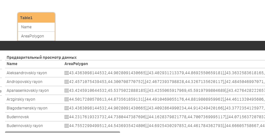
Script code
LOAD
[.Name] as Name,
[.Area] as AreaPolygon
FROM [lib:// [Path your KML file])
Regards,
Andrey
- Mark as New
- Bookmark
- Subscribe
- Mute
- Subscribe to RSS Feed
- Permalink
- Report Inappropriate Content
I'd just seen that function Andrey i'm going to give it a whirl 
- Mark as New
- Bookmark
- Subscribe
- Mute
- Subscribe to RSS Feed
- Permalink
- Report Inappropriate Content
I have a KML file that contains Area and now point data.
when I drop the area field data onto the map it looks like this. Boundaries mapped perfectly,

When I link it to my location data the map seems to lose this understanding of where in the world it is and the area layer returns unsuccessful matching and displays a blank map. Any ideas what can be causing it?
I think I need to be disabling the geographical sevice but not sure what to put in its place.
Regards
Andy
- Mark as New
- Bookmark
- Subscribe
- Mute
- Subscribe to RSS Feed
- Permalink
- Report Inappropriate Content
Hi Andy,
In the attached file, a sample of maps with a layer of area and a layer of points. The source KML file itself suggested splitting the entire area into districts. Therefore, each point represents the center of the district. If you do selections by points, then it will be clearly visible.
Regards,
Andrey
- Mark as New
- Bookmark
- Subscribe
- Mute
- Subscribe to RSS Feed
- Permalink
- Report Inappropriate Content
Currently I'm looking at ways to reduce the size of my KML file. this seems to be the issue.
- « Previous Replies
-
- 1
- 2
- Next Replies »