Unlock a world of possibilities! Login now and discover the exclusive benefits awaiting you.
- Qlik Community
- :
- Forums
- :
- Analytics
- :
- New to Qlik Analytics
- :
- Re: Qlik Map
- Subscribe to RSS Feed
- Mark Topic as New
- Mark Topic as Read
- Float this Topic for Current User
- Bookmark
- Subscribe
- Mute
- Printer Friendly Page
- Mark as New
- Bookmark
- Subscribe
- Mute
- Subscribe to RSS Feed
- Permalink
- Report Inappropriate Content
Qlik Map
Hi all,
I upgraded my Qlik to the April 2018 edition from the previous edition and now I am having an issue with the mapping.
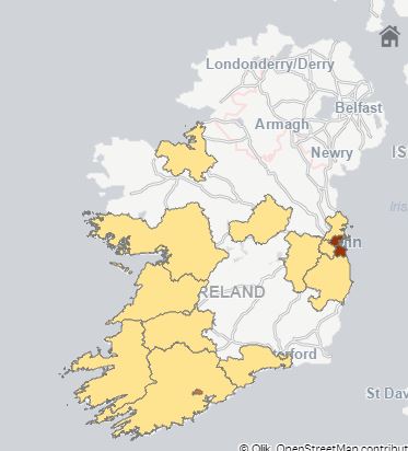
In the map below I displaying the polygons by a measure. The ones that are gray have a measure of 0.
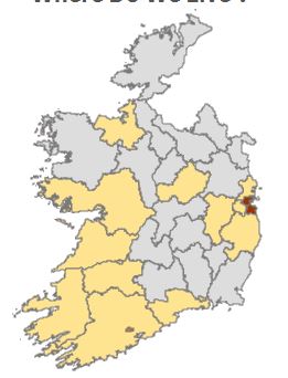
In the new edition when I create the same map, it filters out the grayed out counties which I do not want to happen. Anyone know a work around? I have selected show null values and tried near everything but I can not get it to show the grayed out polygons.
Thanks,
Finbar
- Tags:
- map
- Mark as New
- Bookmark
- Subscribe
- Mute
- Subscribe to RSS Feed
- Permalink
- Report Inappropriate Content
Hi Finbar,
Did you find a solution to this problem? Because I have the same problem and funnily enough, I have one that does work and one that doesn't, but I can't figure out why.
Any help is appreciated.
Casper
- Mark as New
- Bookmark
- Subscribe
- Mute
- Subscribe to RSS Feed
- Permalink
- Report Inappropriate Content
In the Data Model, Do you have the states within the map?
essentially, if a null value exists for Sum(Sales), then that polygon will be shown but it'll be greyed out.
- Mark as New
- Bookmark
- Subscribe
- Mute
- Subscribe to RSS Feed
- Permalink
- Report Inappropriate Content
May be this will help you a bit:
Is the Map chart in Qlik Sense April 2018 ignoring GeoJSON polygons?
- Mark as New
- Bookmark
- Subscribe
- Mute
- Subscribe to RSS Feed
- Permalink
- Report Inappropriate Content
are you using qlik sense desktop or qlik sense server ?