Unlock a world of possibilities! Login now and discover the exclusive benefits awaiting you.
- Qlik Community
- :
- All Forums
- :
- QlikView App Dev
- :
- Re: SVG US County Map not working
- Subscribe to RSS Feed
- Mark Topic as New
- Mark Topic as Read
- Float this Topic for Current User
- Bookmark
- Subscribe
- Mute
- Printer Friendly Page
- Mark as New
- Bookmark
- Subscribe
- Mute
- Subscribe to RSS Feed
- Permalink
- Report Inappropriate Content
SVG US County Map not working
I have been working on creating US State maps with the county regions in them.
I found a site that has all of the states and the SVG for each here. (Georgia is selected since that is the map I am trying to create)
Georgia: free map, free blank map, free outline map, free base map : outline, counties (white)
I have the SVG file copied to here on my dev machine
C:\Users\user.name\AppData\Local\QlikTech\QlikView\Extensions\Objects\svgMap
I believe I have done everything I am supposed to do in order to get the map to work, but it is still not working and I don't understand why.
It will not even show me the map? The map box is just blank.
I have tried opening it in inkscape and saving it. I even tried going through the XML and changing the IDs for the polygons to the County names but that didn't work. I then tried having an excel document and having the original ID names from the map associated to the counties, but that didn't work either. I did not have a chance to change all of the IDs so some were blank... I don't know if that would have caused an issue or not? I really don't want to go through all the work of coding all 159 counties and it still not work.
Any help would be greatly appreciated! Thanks!
- Tags:
- svg map
- « Previous Replies
-
- 1
- 2
- Next Replies »
Accepted Solutions
- Mark as New
- Bookmark
- Subscribe
- Mute
- Subscribe to RSS Feed
- Permalink
- Report Inappropriate Content
Hi Crystal,
I believe you are doing all the correct steps. I was having the same issue and what it appears to be is the SVG itself.
Unless the SVG has a 'fill' attribute set it is not working.
Try the attached SVG and see if this works for you. It has the 'fill' attribute set and was downloaded from commons.wikimedia.org
Hope this helps!
- Stan
- Mark as New
- Bookmark
- Subscribe
- Mute
- Subscribe to RSS Feed
- Permalink
- Report Inappropriate Content
Can you share the screenshot for the SVG Map Settings (Properties)?
- Mark as New
- Bookmark
- Subscribe
- Mute
- Subscribe to RSS Feed
- Permalink
- Report Inappropriate Content
I did find that the borders showed up when I selected the "Element Border" box. Forgot to turn that on before. So it does have the counties outlined... but it isn't letting me click on any other them or using the pop up.

- Mark as New
- Bookmark
- Subscribe
- Mute
- Subscribe to RSS Feed
- Permalink
- Report Inappropriate Content
Seems like Color Measure is not working..
Could you post Color measure you have?
- Mark as New
- Bookmark
- Subscribe
- Mute
- Subscribe to RSS Feed
- Permalink
- Report Inappropriate Content
=If(Sum(MarketShare_ALL) > 10, '#439400', '#F2EF1B')
I'm pretty sure that is the correct syntax and all.
- Mark as New
- Bookmark
- Subscribe
- Mute
- Subscribe to RSS Feed
- Permalink
- Report Inappropriate Content
Can you post a sample?
Check with Region ID: SVG_Code is mapped to your data in location!!
- Mark as New
- Bookmark
- Subscribe
- Mute
- Subscribe to RSS Feed
- Permalink
- Report Inappropriate Content
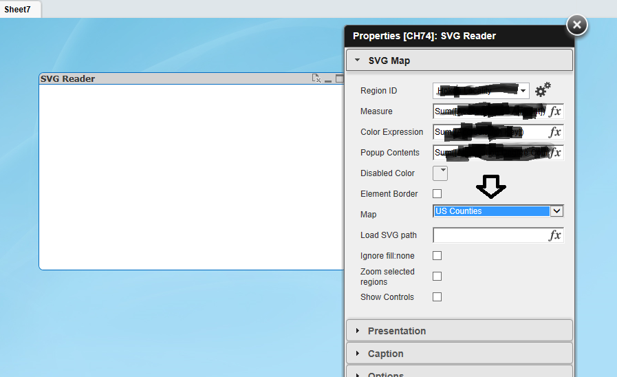
I do not see a Map selected there 'Select or Load Map'
Select 'US Counties' in Map (See the image below)
Also make sure the Region ID is as per SVG acceptance ID.
EX: United States is US (Region ID) or Georgia is GA
If it still doesn't work then change the Georgia SVG file and download a new SVG file.
Thanks.
- Mark as New
- Bookmark
- Subscribe
- Mute
- Subscribe to RSS Feed
- Permalink
- Report Inappropriate Content
Hi Crystal,
I believe you are doing all the correct steps. I was having the same issue and what it appears to be is the SVG itself.
Unless the SVG has a 'fill' attribute set it is not working.
Try the attached SVG and see if this works for you. It has the 'fill' attribute set and was downloaded from commons.wikimedia.org
Hope this helps!
- Stan
- Mark as New
- Bookmark
- Subscribe
- Mute
- Subscribe to RSS Feed
- Permalink
- Report Inappropriate Content
Does this expression seems in css
Can you please let me know the use of #
Instead of use that please use rgb
- Mark as New
- Bookmark
- Subscribe
- Mute
- Subscribe to RSS Feed
- Permalink
- Report Inappropriate Content
I didn't have one of the listed maps selected because I had a downloaded map I was using, so that maps name was in the "Load SVG path".
- « Previous Replies
-
- 1
- 2
- Next Replies »