Unlock a world of possibilities! Login now and discover the exclusive benefits awaiting you.
- Qlik Community
- :
- All Forums
- :
- QlikView App Dev
- :
- Re: See Map in QlikView
- Subscribe to RSS Feed
- Mark Topic as New
- Mark Topic as Read
- Float this Topic for Current User
- Bookmark
- Subscribe
- Mute
- Printer Friendly Page
- Mark as New
- Bookmark
- Subscribe
- Mute
- Subscribe to RSS Feed
- Permalink
- Report Inappropriate Content
See Map in QlikView
Good!
I'm creating a map in QlikView with a Scatter chart, and in the Colors / Image option I put this code:
= 'Http: //maps.googleapis.com/maps/api/staticmap? Center ='
& var_mid_lat
Eur-lex.europa.eu eur-lex.europa.eu
& Var_mid_long & '
& Zoom = $ (var_zoom) '&'
& Maptype = '& var_maptype &'
& Size = '& map_size_x &' x '& map_size_y &'
& Sensor = false '
The first query, is if this is legal or I have to load it another way.
The second query is if you have a limit on the map navigation in QlikView, because, yesterday after having worked during the day, on the map chart I threw an image with the attention sign  And He did not show the map anymore. Today I opened it again and I had no problem seeing it.
Thank you very much for the answer!
Regards,
Ezequiel
- « Previous Replies
-
- 1
- 2
- Next Replies »
- Mark as New
- Bookmark
- Subscribe
- Mute
- Subscribe to RSS Feed
- Permalink
- Report Inappropriate Content
There is no issue with the code you've got.
But Google Maps API's are not totally free anymore. Before it was but when you using the API in production then please make sure you can.
For personal/developing/testing it is free, not in production (this is what I'm aware of).
If there is anyone else who worked or working on Maps can guide you better?
Pricing and Plans | Google Maps APIs Pricing and Plans | Google Developers
Why not use SVG Maps? It is totally free to use. It will be polygon layers but not a bubble style map.
- Mark as New
- Bookmark
- Subscribe
- Mute
- Subscribe to RSS Feed
- Permalink
- Report Inappropriate Content
Thanks for the reply! But how do I apply this SVG map with the QlikView code I have? Thank you! Regards, Ezequiel
- Mark as New
- Bookmark
- Subscribe
- Mute
- Subscribe to RSS Feed
- Permalink
- Report Inappropriate Content
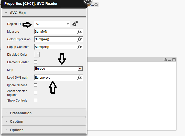
Your code would't work in SVG Maps but if you looking for Europe Map then you need to have Europe's country code which will be
Ex: Country Code
United Kingdom UK
Germany GE
You'll get those ISO codes online for free and then you need to select your country in options in your case Europe
So type in Europe.svg (these maps are pre stored and are static)
You'll also get a pop up option in SVG, color coding can be done as well.
If you have a sample data I'll make an example map for you?
Meanwhile I've attached the SVG extension which you can use and check for your self.
Your region ID will be ISO code for European countries
Map will be Europe
Load path will be europe.svg
And rest is common, color, pop up content, measure...
But this will be a polygon map once you fill in all details
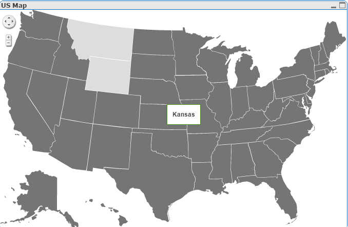
Once you have everything in place the map will populate, below is for US Map which I have created and popup I used is State Name, you cal also use measures and also use a Table box as a pop up in measure.
- Mark as New
- Bookmark
- Subscribe
- Mute
- Subscribe to RSS Feed
- Permalink
- Report Inappropriate Content
Thank you Aehman! I am in Argentina. The SVG extension, where can I get it? Thank you very much!!! Regards, Ezequiel
- Mark as New
- Bookmark
- Subscribe
- Mute
- Subscribe to RSS Feed
- Permalink
- Report Inappropriate Content
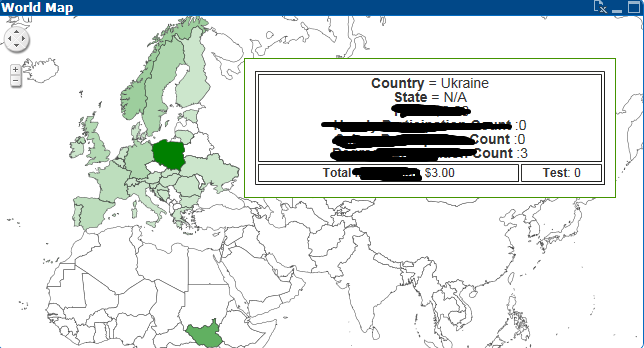
I've attached the extension in my above post below the US Map Image & np. Try it and you'll understand the options, pretty much similar to Google maps.
You can have a hover over Pop up table like below
Here I selected Europe Map with country as Ukraine.
To create a Table Box pop up use the below code in Pop up
= '<table border = "1" style="width: 350px;">' &
'<tbody>' &
'<tr>' &
'<td colspan="2" style="text-align:center;font-size:14px;">' &
'<b>Country</b> = ' & Country & '<br>' &
'<b>State</b> = ' & Your Expression,'N/A') & '<br>' &
'<b>Expression Name</b> = ' & Your Expression), '$#,##0.00') & '<br>' &
'<b> Expression Name </b>:'&Your Expression)&'<br>' &
'<b> Expression Name </b>:'&Your Expression &'<br>' &
'<b> Expression Name </b>:'&Your Expression &
'</td>' &
'</tr>' &
'<tr>' &
'<td style="text-align:center; font-size:12px;">' &
'<b>Total Investment</b>: '& Your Expression
&
'<td style="text-align:center; font-size:12px;">' &
'<b>Test</b>: '& Your Expression
You can add either dimensions or expressions in place of
Your Expression in above code & can have more than 4 or 5 expressions or dimensions as pop in table box. Making sure it doesn't look messy for users.
- Mark as New
- Bookmark
- Subscribe
- Mute
- Subscribe to RSS Feed
- Permalink
- Report Inappropriate Content
Thank you very much!!!
- Mark as New
- Bookmark
- Subscribe
- Mute
- Subscribe to RSS Feed
- Permalink
- Report Inappropriate Content
Good!
With the same code above
"
= 'Http: //maps.googleapis.com/maps/api/staticmap? Center = '
& var_mid_lat
Eur-lex.europa.eu eur-lex.europa.eu
& Var_mid_long & '
& Zoom = $ (var_zoom) '&'
& Maptype = '& var_maptype &'
& Size = '& map_size_x &' x '& map_size_y &'
& Sensor = false '
"
I would like to apply the openstreetmap map since it is free but I do not know how to do it. Can someone help me?
Greetings, Ezequiel
- Mark as New
- Bookmark
- Subscribe
- Mute
- Subscribe to RSS Feed
- Permalink
- Report Inappropriate Content
I was able to incorporate it into QV. But the navigation is very slow (zoom). The code entered was:
= 'Http: //staticmap.openstreetmap.de/staticmap.php? Center ='
& var_mid_lat
Eur-lex.europa.eu eur-lex.europa.eu
& Var_mid_long & '
& Zoom = $ (var_zoom) '&
Regards,
Ezequiel
- Mark as New
- Bookmark
- Subscribe
- Mute
- Subscribe to RSS Feed
- Permalink
- Report Inappropriate Content
You've tried above code in SVG map?
Or which extension are you talking about?
SVG Map will not support the above code. You do not need API's for SVG.
Zoom level will be activated only if a user click on a data point or state.
Please upload a screenshot of what extensions you're using? (Google Maps or SVG?) After knowing that only I can help you better.
Thanks.
- « Previous Replies
-
- 1
- 2
- Next Replies »