Unlock a world of possibilities! Login now and discover the exclusive benefits awaiting you.
- Qlik Community
- :
- All Forums
- :
- QlikView App Dev
- :
- Mapping from a AutoCad DWG file
- Subscribe to RSS Feed
- Mark Topic as New
- Mark Topic as Read
- Float this Topic for Current User
- Bookmark
- Subscribe
- Mute
- Printer Friendly Page
- Mark as New
- Bookmark
- Subscribe
- Mute
- Subscribe to RSS Feed
- Permalink
- Report Inappropriate Content
Mapping from a AutoCad DWG file
Hi
We have a requirement to take a layout created in AutoCAD and overlay it on a map using a mapping extension. We have experimented heavily with NPGeoMap but the issue we have is that the Cad file contains information the mapping software cannot render. Has anyone had experience doing something similar?
Thanks
- « Previous Replies
-
- 1
- 2
- Next Replies »
Accepted Solutions
- Mark as New
- Bookmark
- Subscribe
- Mute
- Subscribe to RSS Feed
- Permalink
- Report Inappropriate Content
Hi Nick,
You already that IdevioMaps can do it, but I wanted to a leave a reference if someone else have the same question.
The Cad file needs to be in some kind of defined reference systems in order to be able to render.
It also help if the cad objects in the drawing contains a usable id field that can be used for indexing.
Thanks
Patric Nordström, Idevio
Try IdevioMaps for Qlik Sense, QlikView and GeoAnalytics Connector at QlikMarket or watch the highlights on video.
- Mark as New
- Bookmark
- Subscribe
- Mute
- Subscribe to RSS Feed
- Permalink
- Report Inappropriate Content
For information, IDEVIO have further developed their GeoAnalystics connector so it can now import DXF files and place them directly onto the map. This process can be initiated just be reloading the application and placing the DXF into a given directory.
- Mark as New
- Bookmark
- Subscribe
- Mute
- Subscribe to RSS Feed
- Permalink
- Report Inappropriate Content
Hi Nick,
Even am stuck with bringing Geo Analytics with Auto CAD DFX file. May i know which version of DFX file supports qliksense/qlikview.
- Mark as New
- Bookmark
- Subscribe
- Mute
- Subscribe to RSS Feed
- Permalink
- Report Inappropriate Content
We created the DFX file from an AutoCAD 2015 DWG file
- Mark as New
- Bookmark
- Subscribe
- Mute
- Subscribe to RSS Feed
- Permalink
- Report Inappropriate Content
Hi Nick, Thanks for your reply. Can you please provide me the steps to import Autocad DWG file into Geo analytics.
- Mark as New
- Bookmark
- Subscribe
- Mute
- Subscribe to RSS Feed
- Permalink
- Report Inappropriate Content
Its not that simple. Like I said we worked with Idevio in order to do this. Idevio were sent our DXF's to which they then tweaked their GeoAnalytics connector to pull the lines and points from our DXF's.
Your best contacting Idevio as your DXF\DWG's may be incompatible.
QLIK has now purchased this connector now so I'm not sure whether they can still help!
- Mark as New
- Bookmark
- Subscribe
- Mute
- Subscribe to RSS Feed
- Permalink
- Report Inappropriate Content
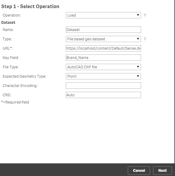
Hi Nick and Nithin,
To import DXF files, use the "Load" operation in the connector.
GeoAnalytics Connector Documentation « bi.idevio.com
Guides & Examples « bi.idevio.com
Thanks,
Patric Nordström
Qlik
- Mark as New
- Bookmark
- Subscribe
- Mute
- Subscribe to RSS Feed
- Permalink
- Report Inappropriate Content
Hi Patric,
I've tried with Pairing DXF file with qliksense.
1.) Installed Java SE
2.) Installed Geoanalytics Connector 5.8
3.) Installed Geoanalytics Plus
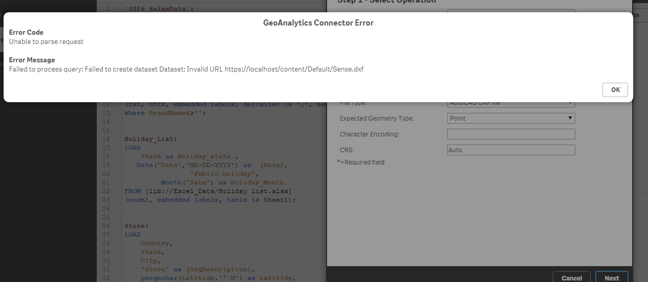
After installing all the applications i placed the downloaded extensions in specific paths. Later if i load the URL am getting this error
- Mark as New
- Bookmark
- Subscribe
- Mute
- Subscribe to RSS Feed
- Permalink
- Report Inappropriate Content
To access local files, use the file:.. url syntax:
file:///C:/Users/bps/Downloads/railways/
- « Previous Replies
-
- 1
- 2
- Next Replies »