Unlock a world of possibilities! Login now and discover the exclusive benefits awaiting you.
- Qlik Community
- :
- All Forums
- :
- QlikView Integrations
- :
- Re: Google Maps - Cluster
- Subscribe to RSS Feed
- Mark Topic as New
- Mark Topic as Read
- Float this Topic for Current User
- Bookmark
- Subscribe
- Mute
- Printer Friendly Page
- Mark as New
- Bookmark
- Subscribe
- Mute
- Subscribe to RSS Feed
- Permalink
- Report Inappropriate Content
Google Maps - Cluster
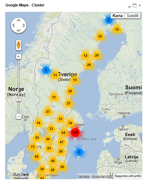
Google Maps Extension with Cluster support.
QlikTech takes no responsibility for any code and QlikTech Support Agreement does not cover issues with this extension.
Please review Googles license agreement before you put this into production.
Introduction
This is a QlikView extension object that integrates Google Maps Javascript API V3 and a third party library called MarkerClusterPlus into QlikView.
Load a set a coordinates into QlikView and visualize them together with this extension. The clustering feature is create when you have alot of data points and needs to group/cluster them together for greater visability and performance.
The maxzoom property defines at what zoom level you want your markers clustered. The grid size property controls how big or small cluster grid size you want.
You can either use the extension 'as is' or use it as a base to further customize it to fit your needs.
Download the extension and view source code at: https://github.com/mindspank/GoogleMaps-Cluster-QV11
If you build something awesome please share it with the community!
Live long and prosper.
2015-02-15
Removed download from post, please grab the latest version from Github instead.
2014-02-03
Various fixes.
2014-01-09
There has been numerous upgrades to the extension.
Now clusters now display the value of your expression and with added support to include more information in pop-up labels.
Example grayscale styled map included.
Possibility to show only a single cluster icon style if you do not want it to scale according to the number of markers in the cluster.
2013-06-17
Added custom marker support. Now you can specify a url for an custom marker. Accepts all major image file types.
- Mark as New
- Bookmark
- Subscribe
- Mute
- Subscribe to RSS Feed
- Permalink
- Report Inappropriate Content
Alexander,
When I click on the marker, I see the infobulles but I can't select the infobulle with my mouse.
The infobulle disappears.
Thank for your help.
- Mark as New
- Bookmark
- Subscribe
- Mute
- Subscribe to RSS Feed
- Permalink
- Report Inappropriate Content
Thanks Alex but that doesn't appear to be working either
Bella
- Mark as New
- Bookmark
- Subscribe
- Mute
- Subscribe to RSS Feed
- Permalink
- Report Inappropriate Content
Yes, that is how the extension works. If you want to switch from onhover to select events instead feel free to change the the code. It's open source and available on GitHub.
- Mark as New
- Bookmark
- Subscribe
- Mute
- Subscribe to RSS Feed
- Permalink
- Report Inappropriate Content
Hi everyone,
Can I use this extension if my QV Server doesn't have the internet ?
Thanks 
- Mark as New
- Bookmark
- Subscribe
- Mute
- Subscribe to RSS Feed
- Permalink
- Report Inappropriate Content
This is a GREAT extension and is creating quite a bit of stirr with some of my clients.
I am wondering if there is any documentation available. One question is just what is passed to Google. It looks as if it is only the Lat/Long coordinates and a marker. Corporate security folks are curious.
- Mark as New
- Bookmark
- Subscribe
- Mute
- Subscribe to RSS Feed
- Permalink
- Report Inappropriate Content
Ugh, documentation... not my strong suit 
All of the properties are described here however: mindspank/GoogleMaps-Cluster-QV11 · GitHub
Yeah the only thing that are passed to google are latitude and longitude.
No other data are sent over the wire, tbh you are sending more corporate data by just surfing to google.com 
- Mark as New
- Bookmark
- Subscribe
- Mute
- Subscribe to RSS Feed
- Permalink
- Report Inappropriate Content
Thanks. Just wanted confirmation. I get the documentation thing too.
Still a great tool.
Norman P. Livermore
MIS Analytics, Enterprise Information Services
SunTrust Bank
Tel: 404.724.3139
Mail Code: GA-ATL-790
303 Peachtree Center Ave., SunTrust Gardens, 3rd Floor, Suite 325
Atlanta, GA 30303
How Can We Help You Shine Today?
- Mark as New
- Bookmark
- Subscribe
- Mute
- Subscribe to RSS Feed
- Permalink
- Report Inappropriate Content
The code is open source so feel free to steal, modify, enhance to your liking.
Adding more custom requirements is usually very fast but between the marker, cluster and heatmap extensions I think I cover like 90% of the use cases for plotting points.
- Mark as New
- Bookmark
- Subscribe
- Mute
- Subscribe to RSS Feed
- Permalink
- Report Inappropriate Content
The cluster is a PERFECT extension to the mapping using Google. We, like most I would think have clusters and the other way just makes things too busy. Best of both worlds in the cluster extension. Good stuff.
Norman P. Livermore
MIS Analytics, Enterprise Information Services
SunTrust Bank
Tel: 404.724.3139
Mail Code: GA-ATL-790
303 Peachtree Center Ave., SunTrust Gardens, 3rd Floor, Suite 325
Atlanta, GA 30303
How Can We Help You Shine Today?
- Mark as New
- Bookmark
- Subscribe
- Mute
- Subscribe to RSS Feed
- Permalink
- Report Inappropriate Content
Hi @candice1973! I have the same problem, can you resolve it?@