Unlock a world of possibilities! Login now and discover the exclusive benefits awaiting you.
- Qlik Community
- :
- All Forums
- :
- QlikView Integrations
- :
- Re: Image mapping in qlikview on static image
- Subscribe to RSS Feed
- Mark Topic as New
- Mark Topic as Read
- Float this Topic for Current User
- Bookmark
- Subscribe
- Mute
- Printer Friendly Page
- Mark as New
- Bookmark
- Subscribe
- Mute
- Subscribe to RSS Feed
- Permalink
- Report Inappropriate Content
Image mapping in qlikview on static image
Hi Guys,
I wish to develop a report we can highlight the particular part of image. we have floor plate or map of building representing suit in each floor. whenever a suit is selected from list it highlight the outline respective suit in the floor map image
please see the attached image what i want to achieve 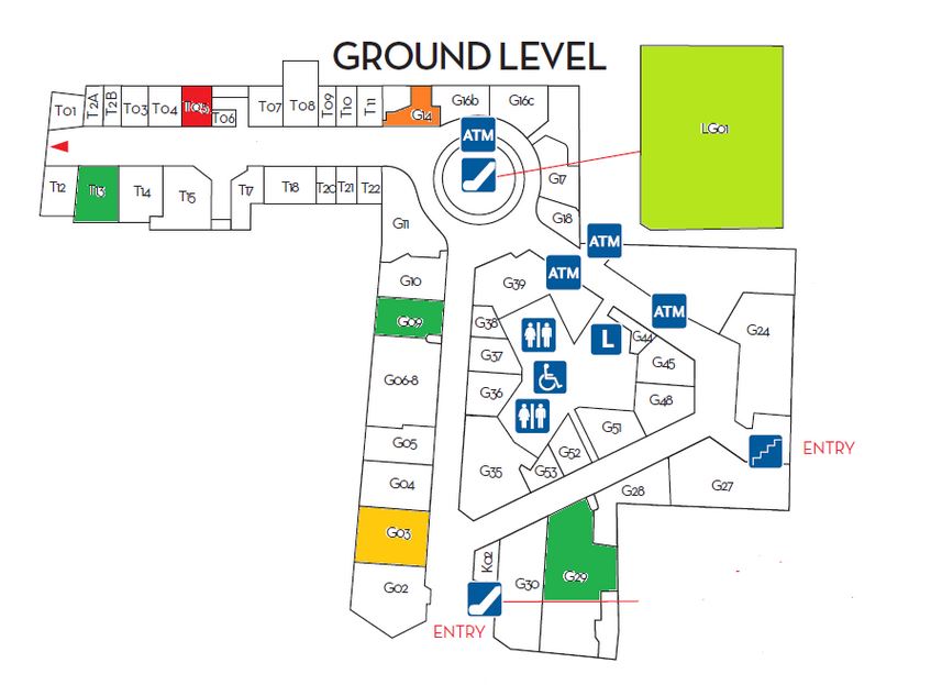
- Tags:
- qlikview_extensions
Accepted Solutions
- Mark as New
- Bookmark
- Subscribe
- Mute
- Subscribe to RSS Feed
- Permalink
- Report Inappropriate Content
Hi Ramu,
I'd recommend you to take a look at the SvgReader extensionSvgReader mapping extension now stored on GitHub
The basic concept is that you use a SVG image and the polygons in the image can be linked to your QV data. Its most typical use is with maps, but can also be applied to floorplans. I've seen Brian Munz demonstrating this extension in a qv app, he used an image with a snail's body parts. You can find this image in the github repositry... 
Hope this helps
Fernando
- Mark as New
- Bookmark
- Subscribe
- Mute
- Subscribe to RSS Feed
- Permalink
- Report Inappropriate Content
Refer Static image example in google map , Insted of India Map you need to take your pics in map.
Hope this help you.
Vikas
If the issue is solved please mark the answer with Accept as Solution & like it.
If you want to go quickly, go alone. If you want to go far, go together.
- Mark as New
- Bookmark
- Subscribe
- Mute
- Subscribe to RSS Feed
- Permalink
- Report Inappropriate Content
may be you can use google map but may it do not solve your problem
- Mark as New
- Bookmark
- Subscribe
- Mute
- Subscribe to RSS Feed
- Permalink
- Report Inappropriate Content
I am unable to open the file, seems some license issue with my qlik view. Can you please guide me steps how achieve this
Regards
Ramu
- Mark as New
- Bookmark
- Subscribe
- Mute
- Subscribe to RSS Feed
- Permalink
- Report Inappropriate Content
Hi Ramu,
I'd recommend you to take a look at the SvgReader extensionSvgReader mapping extension now stored on GitHub
The basic concept is that you use a SVG image and the polygons in the image can be linked to your QV data. Its most typical use is with maps, but can also be applied to floorplans. I've seen Brian Munz demonstrating this extension in a qv app, he used an image with a snail's body parts. You can find this image in the github repositry...
Hope this helps
Fernando
- Mark as New
- Bookmark
- Subscribe
- Mute
- Subscribe to RSS Feed
- Permalink
- Report Inappropriate Content
Thanks Fernando,
I also found this but only issue i am facing here is how the image i am having svg file. online convert are not that worthy.
I am looking for tool or something that will convert it to perfect svg file
regards
Ramu
- Mark as New
- Bookmark
- Subscribe
- Mute
- Subscribe to RSS Feed
- Permalink
- Report Inappropriate Content
Ramu,
I've already used the SVGReader with a custom SVG. My source was a shapefile map, had to use a GIS software to convert it to a SVG image, but the xml data from the SVG wasn't good for the extension. I had to do some heavy manual editing in the xml to make it work with the extension. But the result was worth it! 
The key for a good SVG file is that in the XML code each path (polygon) must have an ID, and then you must have this same ID in your data model so that you can link them.
- Mark as New
- Bookmark
- Subscribe
- Mute
- Subscribe to RSS Feed
- Permalink
- Report Inappropriate Content
Hi Guys,
How can add a image in the back ground of SVG Image and display the same in qlikview, as this will improve the visibility of the floor image.
Kind regards
Ramu