Unlock a world of possibilities! Login now and discover the exclusive benefits awaiting you.

- Qlik Community
- :
- Forums
- :
- Analytics & AI
- :
- Products & Topics
- :
- Visualization and Usability
- :
- Map Object and GeoMakePoint()
- Subscribe to RSS Feed
- Mark Topic as New
- Mark Topic as Read
- Float this Topic for Current User
- Bookmark
- Subscribe
- Mute
- Printer Friendly Page

- Mark as New
- Bookmark
- Subscribe
- Mute
- Subscribe to RSS Feed
- Permalink
- Report Inappropriate Content
Map Object and GeoMakePoint()
I would like to create a Map based on the cities (that's my Geo point) and number of sites for each company on the region (bubble size)
The issue is that when plotting based on the name of the city for each company, the map doesn't distinguish between the same name of the city in different countries (for example the city Odessa from USA is shown in Ukraina on the city of Odessa).
So I tried a different approach: I created a Location with GeoMakePoint (longitude, latitude) to have the exact location of the cities from USA that I need to plot. But the map looks like the map in the right and the points based on longitude and latitude are plotted very badly.
The map on the left is based on name of the city, my first approach, and looks good but can't distinguish between countries when I have the same name of the city.
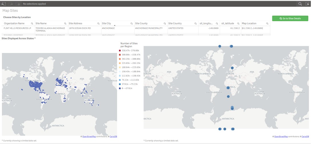
Any ideas why the points are so badly placed on the map based on the longitude and latitude? Thanks,
- Tags:
- us map

 MK9885
- Mark as New
- Bookmark
- Subscribe
- Mute
- Subscribe to RSS Feed
- Permalink
- Report Inappropriate Content
The default Maps from Qlik Sense only plots data points based on Lat & Long.
It won't take the name of the Cities or states into consideration as the names can be same in different parts of world.
Check the latitude and longitude in google if they showing you correct city?
Geo Mapping cannot be auto generated and we cannot provide the result you looking for? Perhaps sample data would help?