Unlock a world of possibilities! Login now and discover the exclusive benefits awaiting you.

- Qlik Community
- :
- Forums
- :
- Analytics & AI
- :
- Products & Topics
- :
- Visualization and Usability
- :
- Qliksense - what happened with my map visualisatio...
- Subscribe to RSS Feed
- Mark Topic as New
- Mark Topic as Read
- Float this Topic for Current User
- Bookmark
- Subscribe
- Mute
- Printer Friendly Page

 josephinetedesc
- Mark as New
- Bookmark
- Subscribe
- Mute
- Subscribe to RSS Feed
- Permalink
- Report Inappropriate Content
Qliksense - what happened with my map visualisation?
Hi All
I was happy as - yesterday my laptop showed beautifully data against the background of the map of the world - today I see the circles but no map. The only difference I can see - when I try to recreate it is -
I get a popup asking: about add as area layer add as points layer???
Jo
josephinetedesc
- Mark as New
- Bookmark
- Subscribe
- Mute
- Subscribe to RSS Feed
- Permalink
- Report Inappropriate Content
I think maybe it was because I was not connected to the network as - it now shows like it did yesterday! phew!
- however stating another sheet gave me the same question re points and area layer.
Jo

 pablolabbe
- Mark as New
- Bookmark
- Subscribe
- Mute
- Subscribe to RSS Feed
- Permalink
- Report Inappropriate Content
HI Jo,
You need access to internet to see the map background.
Without internet it only show the polygons or bubbles.
Pablo
josephinetedesc
- Mark as New
- Bookmark
- Subscribe
- Mute
- Subscribe to RSS Feed
- Permalink
- Report Inappropriate Content
thank you
josephinetedesc
- Mark as New
- Bookmark
- Subscribe
- Mute
- Subscribe to RSS Feed
- Permalink
- Report Inappropriate Content
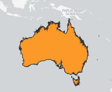
do you know why when the country shows it then has the outline as feathery
pablolabbe
- Mark as New
- Bookmark
- Subscribe
- Mute
- Subscribe to RSS Feed
- Permalink
- Report Inappropriate Content
What do you mean with "feathery". Can you share a screenshot ?
josephinetedesc
- Mark as New
- Bookmark
- Subscribe
- Mute
- Subscribe to RSS Feed
- Permalink
- Report Inappropriate Content
I am working on laptop and desktop - so not that easy but!
I think I know what the problem is: A postcode may have more than one suburb and therefore more than one latitude and longitude. So I need to prepare the data?
josephinetedesc
- Mark as New
- Bookmark
- Subscribe
- Mute
- Subscribe to RSS Feed
- Permalink
- Report Inappropriate Content
pablolabbe
- Mark as New
- Bookmark
- Subscribe
- Mute
- Subscribe to RSS Feed
- Permalink
- Report Inappropriate Content
probably a problem with the data you are using to draw the area layer. Are you using a kml ?
josephinetedesc
- Mark as New
- Bookmark
- Subscribe
- Mute
- Subscribe to RSS Feed
- Permalink
- Report Inappropriate Content
no - out of Qliksense - I did a vlookup in Excel to get the lats and longs for the postcodes. The problem with the feathery map - I think was due to no internet. It could also have been that I need to further refine the list of postcodes and ongs and lats.
Jo
