Unlock a world of possibilities! Login now and discover the exclusive benefits awaiting you.
Announcements
Now accepting applications for the Qlik Luminary and Partner Ambassador Programs: Apply by July 6!
- Qlik Community
- :
- Forums
- :
- Analytics & AI
- :
- Products & Topics
- :
- Visualization and Usability
- :
- Strange thing regarding Map Chart
Options
- Subscribe to RSS Feed
- Mark Topic as New
- Mark Topic as Read
- Float this Topic for Current User
- Bookmark
- Subscribe
- Mute
- Printer Friendly Page
Turn on suggestions
Auto-suggest helps you quickly narrow down your search results by suggesting possible matches as you type.
Showing results for
Creator III
2018-03-27
12:24 PM
- Mark as New
- Bookmark
- Subscribe
- Mute
- Subscribe to RSS Feed
- Permalink
- Report Inappropriate Content
Strange thing regarding Map Chart
Hi everyone,
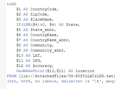
I downloaded US.zip from GeoNames, and tried to create a map chart based on zip code. This is my script:
But the map shows like this:
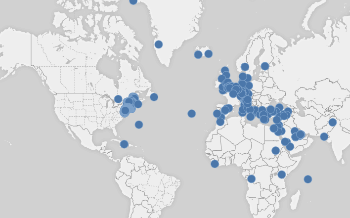
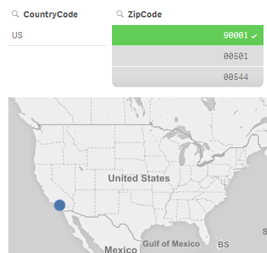
Which doesn't make sense, because all dots should be in US. And many dots are not shown. Like in CA, there is a dot with zip code 90001. It will be shown only with the filter:
Any ideas what the problem is?
4,817 Views
- « Previous Replies
-
- 1
- 2
- Next Replies »
10 Replies
MVP
2018-03-27
05:48 PM
- Mark as New
- Bookmark
- Subscribe
- Mute
- Subscribe to RSS Feed
- Permalink
- Report Inappropriate Content
Yes.
271 Views
- « Previous Replies
-
- 1
- 2
- Next Replies »