Unlock a world of possibilities! Login now and discover the exclusive benefits awaiting you.
- Qlik Community
- :
- All Forums
- :
- QlikView
- :
- Google Maps - Cluster
- Subscribe to RSS Feed
- Mark Topic as New
- Mark Topic as Read
- Float this Topic for Current User
- Bookmark
- Subscribe
- Mute
- Printer Friendly Page
- Mark as New
- Bookmark
- Subscribe
- Mute
- Subscribe to RSS Feed
- Permalink
- Report Inappropriate Content
Google Maps - Cluster
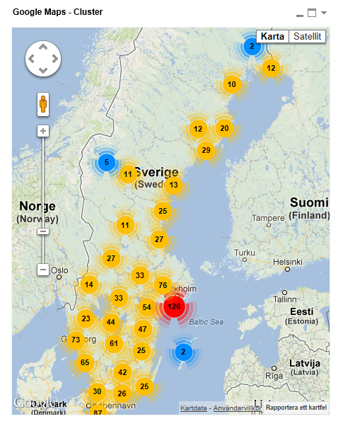
Google Maps Extension with Cluster support.
QlikTech takes no responsibility for any code and QlikTech Support Agreement does not cover issues with this extension.
Please review Googles license agreement before you put this into production.
Introduction
This is a QlikView extension object that integrates Google Maps Javascript API V3 and a third party library called MarkerClusterPlus into QlikView.
Load a set a coordinates into QlikView and visualize them together with this extension. The clustering feature is create when you have alot of data points and needs to group/cluster them together for greater visability and performance.
The maxzoom property defines at what zoom level you want your markers clustered. The grid size property controls how big or small cluster grid size you want.
You can either use the extension 'as is' or use it as a base to further customize it to fit your needs.
Download the extension and view source code at: https://github.com/mindspank/GoogleMaps-Cluster-QV11
If you build something awesome please share it with the community!
Live long and prosper.
2015-02-15
Removed download from post, please grab the latest version from Github instead.
2014-02-03
Various fixes.
2014-01-09
There has been numerous upgrades to the extension.
Now clusters now display the value of your expression and with added support to include more information in pop-up labels.
Example grayscale styled map included.
Possibility to show only a single cluster icon style if you do not want it to scale according to the number of markers in the cluster.
2013-06-17
Added custom marker support. Now you can specify a url for an custom marker. Accepts all major image file types.
- Tags:
- clustering
- extension
- extension_object
- geospatial
- google cluster maps
- google maps
- javascript
- map
- mapping
- qlikview extensions
- qlikview_extensions
- « Previous Replies
- Next Replies »
- Mark as New
- Bookmark
- Subscribe
- Mute
- Subscribe to RSS Feed
- Permalink
- Report Inappropriate Content
Hi Alex
I really need your help on this topic (http://community.qlik.com/message/325846#325846).
I am not able to get maps on the QlikView in addition I have a this complex requirement.
Can you help.... ?
Thanks
- Mark as New
- Bookmark
- Subscribe
- Mute
- Subscribe to RSS Feed
- Permalink
- Report Inappropriate Content
Alexander,
I only get the sample app to work in Server mode but it doesn't work in Desktop using the Web View functionality. Is this the expected behavior?
thanks,
Jesus
- Mark as New
- Bookmark
- Subscribe
- Mute
- Subscribe to RSS Feed
- Permalink
- Report Inappropriate Content
Hmm - nope should work in desktop also.
You got IE10 installed? Do you get any errors? We use IE components for web view which currently is working less then great with IE10...
- Mark as New
- Bookmark
- Subscribe
- Mute
- Subscribe to RSS Feed
- Permalink
- Report Inappropriate Content
I have IE 9. May be that is the problem?
- Mark as New
- Bookmark
- Subscribe
- Mute
- Subscribe to RSS Feed
- Permalink
- Report Inappropriate Content
Should work with IE9 - you get no errors what so ever?
I know the extension might behave a little bit funky if you load non coordinates as latitude/longitude dimensions but the attached app should work. Let me install internet explorer and test it.
- Mark as New
- Bookmark
- Subscribe
- Mute
- Subscribe to RSS Feed
- Permalink
- Report Inappropriate Content
- Mark as New
- Bookmark
- Subscribe
- Mute
- Subscribe to RSS Feed
- Permalink
- Report Inappropriate Content
Just installed IE9, running QV11SR1, Win7 64-bit, downloaded the attached sample and extension and it worked fine.
Try to turn of web view, remove the map, save, turn on web view and add the map again. Seen that error before with other extensions but never tracked down the root cause.
Edit: Oh and if you have UAC turned on you might need to run QV as administrator.
- Mark as New
- Bookmark
- Subscribe
- Mute
- Subscribe to RSS Feed
- Permalink
- Report Inappropriate Content
Hi Alex
I am running IE9, QV11SR2, Win 7 64-bit.
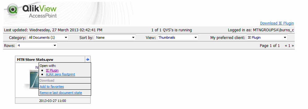
The cluster map works on the QV Client but not on the access point.
Read that it only works with AJAX Client & not IE Plugin (which is what I have selected when loading the model via the access point).
We installed the extension on the QV server as well (where the live model is) and ran the GoogleMaps - Cluster.qar with success.
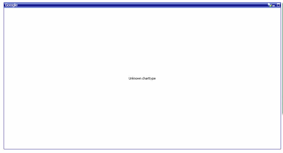
When you select AJAX the object does not show at all, when you select IE Plugin the object is there but it says"unknown chart type"
Otherwise the extension works beautifully but only on the client and not on the access point. Please help if you can.
Thanx Candice
Examples below:-
- Mark as New
- Bookmark
- Subscribe
- Mute
- Subscribe to RSS Feed
- Permalink
- Report Inappropriate Content
I've tested this in two app's, one it works fine, the other I get the following error (it's actually the same error and same app I have the problem with for the markers as well):
Stack Overflow at line 24
The first app is a small dataset (under 10,000), the second app is larger (about 150,000), however I have cut it down to under 10,000 and still get the error ..
Any ideas? By the way, I'm good at Quality Management as I invariably break stuff!!
- « Previous Replies
- Next Replies »