Unlock a world of possibilities! Login now and discover the exclusive benefits awaiting you.
- Qlik Community
- :
- All Forums
- :
- GeoAnalytics
- :
- Re: GeoAnalytics - Aggregate Areas
- Subscribe to RSS Feed
- Mark Topic as New
- Mark Topic as Read
- Float this Topic for Current User
- Bookmark
- Subscribe
- Mute
- Printer Friendly Page
- Mark as New
- Bookmark
- Subscribe
- Mute
- Subscribe to RSS Feed
- Permalink
- Report Inappropriate Content
GeoAnalytics - Aggregate Areas
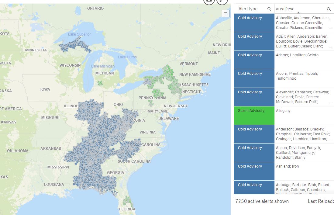
I have a frequently reloaded dataset of US Postal Codes that are associated with current weather alerts. typically, there are 5000+ records in the dataset, and it means that rendering each respective area brings down app performance. Any recommendations on how to aggregate the county areas created by the postal codes for each weather alert and create one large alert area? Screenshot of the current map below. Thanks!
Accepted Solutions
- Mark as New
- Bookmark
- Subscribe
- Mute
- Subscribe to RSS Feed
- Permalink
- Report Inappropriate Content
Hi,
Please take a look here:
and this small example:
http://bi.idevio.com/wp-content/qlik/qliksense/Apps/DissolveDemo.qvf
All the settings is documented in the script
Guides & Examples « bi.idevio.com
The areas don´t have to be contiguous.
BR
/Jonas
- Mark as New
- Bookmark
- Subscribe
- Mute
- Subscribe to RSS Feed
- Permalink
- Report Inappropriate Content
Hi Joe,
You can follow the guides and examples here http://bi.idevio.com/products/idevio-maps-for-qlik-sense/qlik-sense-2
For example this one: GeoAnalytics Dissolve
You can also checkout the Fast Foof USA demo whick includes an US drill down. https://qm-sense.qlik.com/sense/app/b7bfb9ea-f9f0-4dc4-a67d-e0440c4e840a
And of course this will requires a Qlik GeoAnalytics license which I assume you´ve got.
When applicable please mark the appropriate replies as CORRECT. This will help community members and Qlik Employees know which discussions have already been addressed and have a possible known solution. Please mark threads as HELPFUL if the provided solution is helpful to the problem, but does not necessarily solve the indicated problem. You can mark multiple threads as HELPFUL if you feel additional info is useful to others.
Regards,
Jonas Karlsson
Qlik
- Mark as New
- Bookmark
- Subscribe
- Mute
- Subscribe to RSS Feed
- Permalink
- Report Inappropriate Content
Thanks for the Quick follow up. i am having trouble configuring the connector to do what i want.
Relevant fields:
[AlertArea] = us postal code of the alert
[event] = the type of weather alert
[alertID] = table key
table name is "Alerts"
how do i set up the GAConnector to dissolve alert areas into an "event area"?
also - do the dissolved areas have to be contiguous, or will several "blobs" be created if there are several unconnected areas?
- Mark as New
- Bookmark
- Subscribe
- Mute
- Subscribe to RSS Feed
- Permalink
- Report Inappropriate Content
Hi,
Please take a look here:
and this small example:
http://bi.idevio.com/wp-content/qlik/qliksense/Apps/DissolveDemo.qvf
All the settings is documented in the script
Guides & Examples « bi.idevio.com
The areas don´t have to be contiguous.
BR
/Jonas
- Mark as New
- Bookmark
- Subscribe
- Mute
- Subscribe to RSS Feed
- Permalink
- Report Inappropriate Content
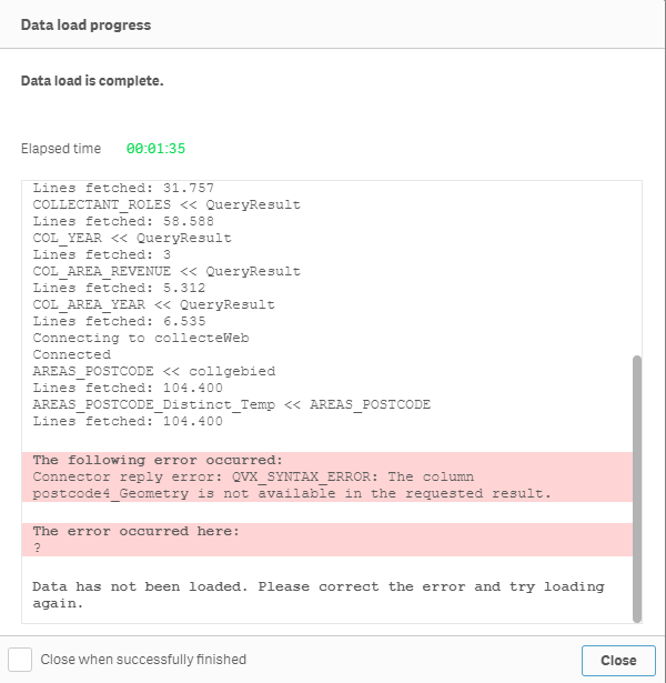
Hi Jonas or anyone knowing the answers,
I’m trying to do the same as Joe and tried to follow your solutions. At this point I’m seting a new operation but get an invalid column name error which is strange because all columns used exist.

Do you know what i'm doing wrong?
- Mark as New
- Bookmark
- Subscribe
- Mute
- Subscribe to RSS Feed
- Permalink
- Report Inappropriate Content
Hi Arne,
Table Fields needs to include all fields that you want to use, so in your case:
postcode4, pc_areaId
Thanks,
Patric
- Mark as New
- Bookmark
- Subscribe
- Mute
- Subscribe to RSS Feed
- Permalink
- Report Inappropriate Content
Thanks Patric for your quick response,
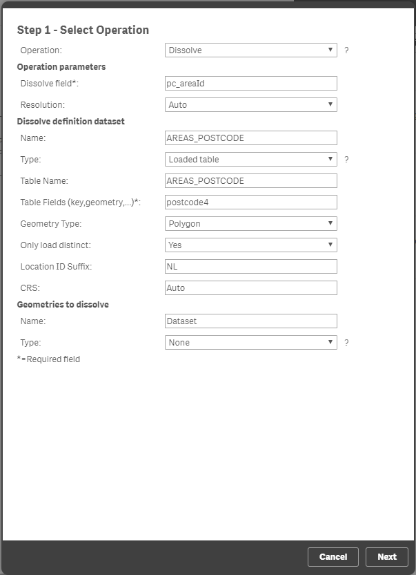
You were right about the Table field entry and after some other changes I came past the operation form. I noticed that in the example in the table field in the SQL statement it shows “tableFields='State,State,SalesArea'“ while I just get “tableFields='postcode4,pc_areaId'”. I tried with a 2nd potcode4 field but that failed. Can you explain why this is?
Also I’m using postal codes which (in my case) get plotted on the map by polygons but I do not get the code to load with that (see error image below) so I changed that to “geometryType='LOCATIONNAMEDAREA'”. Do you know why that is?
After all that the code does load but when I set up the map in the app I get a very different result. Sometimes even four overlaying area’s while the date was loaded in with the “loadDistinct='YES'”.
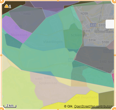
So I ran a little test to see what happens in the example if there are two states with the same name assigned to different sales areas but it got just inserted in the last sales area. Therefore I think there is still something is going wrong in my app.
Sorry for the long post but I find this to be a difficult part of QS and till now I could not find a good guide that explains why things go right or wrong.
- Mark as New
- Bookmark
- Subscribe
- Mute
- Subscribe to RSS Feed
- Permalink
- Report Inappropriate Content
Hi Arne,
Sorry I didnt see that part. You specify key, geometry and other field in "Table fields".
In your example the key is postcode4, the geometry is also postcode4, and the last field pc_areaId.
But in this case your geometry needs to be looked up, so use
the Geometry Type: Location Named Area instead of Polygon.
Table fields: postcode4, postcode4, pc_areaId
Note, it might be wise to split up the operation if some postal codes may be invalid. If so use the operation "NamedAreaLokup" first to get the geometries as Polygon.
Thanks,
Patric