Unlock a world of possibilities! Login now and discover the exclusive benefits awaiting you.
- Qlik Community
- :
- Forums
- :
- Analytics & AI
- :
- Products & Topics
- :
- App Development
- :
- Re: Custom KML - Display Area Label
- Subscribe to RSS Feed
- Mark Topic as New
- Mark Topic as Read
- Float this Topic for Current User
- Bookmark
- Subscribe
- Mute
- Printer Friendly Page
- Mark as New
- Bookmark
- Subscribe
- Mute
- Subscribe to RSS Feed
- Permalink
- Report Inappropriate Content
Custom KML - Display Area Label
Dear All,
Greetings!
I am new to using custom KML in Qlik Sense Map reports. I use Qlik Sense June 2017 version. I am trying to build a visualization where I try show the seat layout from a theatre or bus in a Qlik Sense Area map. I have seats in 8 columns (A,B,C,D,E,F.G,H) and 30 rows and in my sample data I have added the Occupancy % and Revenue genrated from those seats.
I was able to build a KML file and ingest few seat location details there and I am able to view the Occupancy and Revenue generated from those seating locations.
However my map doesnot display the label for the seat (A1, B1, A2 etc). The map displays the seat number only when i hover over it. Can you please let me know how the labels for the seats can be displayed into the seat location (inside the square )
I have attached the QVF and the KML file for your reference.
Please let me know if you need more details.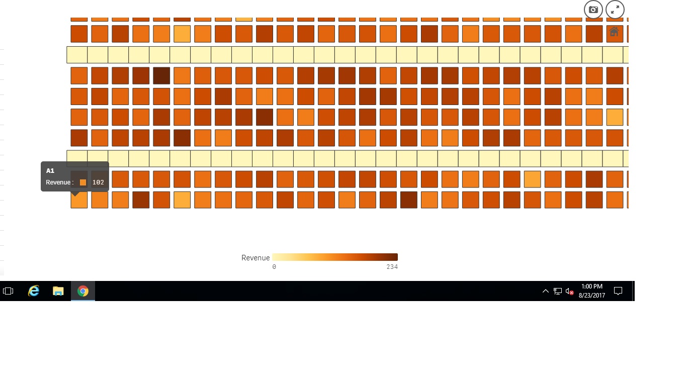
- Tags:
- custom kml
- « Previous Replies
-
- 1
- 2
- Next Replies »
Accepted Solutions
- Mark as New
- Bookmark
- Subscribe
- Mute
- Subscribe to RSS Feed
- Permalink
- Report Inappropriate Content
Hi Aushik,
I think your solution to align a background image with your seat number, is the best one
I never tried to change the background but I guess (I hope) it's possible in Sense
In QlikView, I would have tried to use a table chart (with custom color) but I don't think it's possible in Sense
Good luck 
- Mark as New
- Bookmark
- Subscribe
- Mute
- Subscribe to RSS Feed
- Permalink
- Report Inappropriate Content
Hello Ausik - let me see if one of our resident community heroes may have a suggestion.
gwassenaar - is this something you are familiar with, can you please take a look?
When applicable please mark the appropriate replies as CORRECT. This will help community members and Qlik Employees know which discussions have already been addressed and have a possible known solution. Please mark threads as HELPFUL if the provided solution is helpful to the problem, but does not necessarily solve the indicated problem. You can mark multiple threads as HELPFUL if you feel additional info is useful to others.
Regards,
Michael Tarallo (@mtarallo) | Twitter
Qlik
Mike Tarallo
Qlik
- Mark as New
- Bookmark
- Subscribe
- Mute
- Subscribe to RSS Feed
- Permalink
- Report Inappropriate Content
Hello Community - is there anyone with some knowledge on this area that can assist Aushik?
Mike Tarallo
Qlik
- Mark as New
- Bookmark
- Subscribe
- Mute
- Subscribe to RSS Feed
- Permalink
- Report Inappropriate Content
I'm not a KML export but I think the only way is to include the seat number as a multigeometry object
> instead of having a simple square for your object, you should include the label into the object itself
I don't think Sense is able to handle extra properties (name of the object) of the KML to display it directly in the map
- Mark as New
- Bookmark
- Subscribe
- Mute
- Subscribe to RSS Feed
- Permalink
- Report Inappropriate Content
Hi Nicholas
Many thanks for coming back on this topic. I tried to include a multigeometry object which has the polygon and the centre point. Still the label doesnot display.
Sample below.
******************************************************************
<?xml version="1.0" encoding="UTF-8"?>
<kml xmlns="http://www.opengis.net/kml/2.2">
<Document>
<name>Seat</name>
<open>1</open>
<Folder>
<name>1</name>
<LookAt>
<longitude>0</longitude>
<latitude>0</latitude>
<altitude>0</altitude>
</LookAt>
<Placemark>
<name>BUS-A1</name>
<multigeometry>
<Polygon>
<extrude>1</extrude>
<altitudeMode>relativeToGround</altitudeMode>
<outerBoundaryIs>
<LinearRing>
<coordinates>
4.25,2.25,0
6.25,2.25,0
6.25,4.25,0
4.25,4.25,0
4.25,2.25,0
</coordinates>
</LinearRing>
</outerBoundaryIs>
</Polygon>
<Point>
<coordinates>5.0,3.0,0 </coordinates>
</Point>
</multigeometry>
</Placemark>
</Folder>
</Document>
</kml>
***********************************************************************************
I am missing something in the kml content below. I just want to display the polygon name 'BUS-A1' in the centre of the square Can you please help ?
Or can this issue be solved by pairing a background image with this kml co-ordinates ?
Many Thanks!
Best Regards
M.Aushik
- Mark as New
- Bookmark
- Subscribe
- Mute
- Subscribe to RSS Feed
- Permalink
- Report Inappropriate Content
Hi Aushik,
I think your solution to align a background image with your seat number, is the best one
I never tried to change the background but I guess (I hope) it's possible in Sense
In QlikView, I would have tried to use a table chart (with custom color) but I don't think it's possible in Sense
Good luck
- Mark as New
- Bookmark
- Subscribe
- Mute
- Subscribe to RSS Feed
- Permalink
- Report Inappropriate Content
Hi Aushik,
I'm working on something similar but I am a step back - how did you build your seat map?
Thanks,
Adina
- Mark as New
- Bookmark
- Subscribe
- Mute
- Subscribe to RSS Feed
- Permalink
- Report Inappropriate Content
Hi Adina,
I built this seat map using a KML file and this KML was built using java script to build the co-ordinates for each seat. (After building the code I had to remove the space in '< ' and replace with '<' manually. I am new to JS. You can let me know if there is any better way to do it.
Java script and KML file attached for your reference.
Also if you are able to build the polygon 'label' into the file by any means please let me know as I am looking for the same.
Thanks!
BR
Aushik
- Mark as New
- Bookmark
- Subscribe
- Mute
- Subscribe to RSS Feed
- Permalink
- Report Inappropriate Content
Thanks Aushik! Same here. I worked with JS only few times in the past and building such map from scratch is quite a challenge. Have you used any program to design the layout and generate the JS automatically?
- Mark as New
- Bookmark
- Subscribe
- Mute
- Subscribe to RSS Feed
- Permalink
- Report Inappropriate Content
Hi Nicolas,
Many thanks for your suggestion. But do you know if any tweak in my kml can bring in the polygon label ?
Best Regards
M.Aushik
- « Previous Replies
-
- 1
- 2
- Next Replies »