Unlock a world of possibilities! Login now and discover the exclusive benefits awaiting you.
- Qlik Community
- :
- All Forums
- :
- GeoAnalytics
- :
- Dissolve
- Subscribe to RSS Feed
- Mark Topic as New
- Mark Topic as Read
- Float this Topic for Current User
- Bookmark
- Subscribe
- Mute
- Printer Friendly Page
- Mark as New
- Bookmark
- Subscribe
- Mute
- Subscribe to RSS Feed
- Permalink
- Report Inappropriate Content
Dissolve
Hi all,
I am using the below file and i want to dissolve 'D' on the basis of zip codes.
I used the following script:
Zipcodes:
LOAD
ZIP,
GeoMakePoint(LAT,LNG) as GeoInfo,
D
FROM [lib://AttachedFiles/US Zip Codes from 2013 Government Data.xlsx]
(ooxml, embedded labels, table is [US Zip Codes from 2013 Governme]);
TAG FIELD [ZIP] WITH '$geoname', '$relates_Zipcodes.GeoInfo' ;
TAG FIELD [Zipcodes.GeoInfo] WITH '$geopoint', '$hidden', '$relates_ZIP' ;

And the settings i have used are:
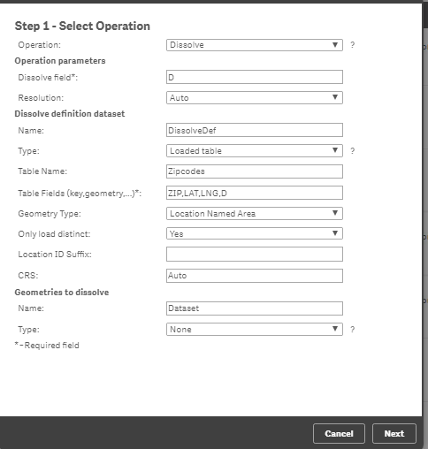
this isnt working fine. I am not abl to plot East, Middle and West region on the map.
Can anyone help?
- Mark as New
- Bookmark
- Subscribe
- Mute
- Subscribe to RSS Feed
- Permalink
- Report Inappropriate Content
Hello Chhavi,
The dissolve function only works with AREA's geometries (polygons) does not work with Points. You would have to generate the geometries of the ZIP CODES to then apply the Dissolve.
According to the help:
"Dissolves and simplifies areas to form larger areas based on a mapping between old area identities (or geometries) and new area identities."
Greetings,