Unlock a world of possibilities! Login now and discover the exclusive benefits awaiting you.

Announcements
Share your agentic AI experience, learn from others, and earn a new badge: Put Agentic AI to Work
- Qlik Community
- :
- All Forums
- :
- GeoAnalytics
- :
- Re: Error QVX_SYNTAX_ERROR
Options
- Subscribe to RSS Feed
- Mark Topic as New
- Mark Topic as Read
- Float this Topic for Current User
- Bookmark
- Subscribe
- Mute
- Printer Friendly Page
Turn on suggestions
Auto-suggest helps you quickly narrow down your search results by suggesting possible matches as you type.
Showing results for

 3vecesleo
Contributor
2020-03-12
01:20 PM
- Mark as New
- Bookmark
- Subscribe
- Mute
- Subscribe to RSS Feed
- Permalink
- Report Inappropriate Content
Error QVX_SYNTAX_ERROR
please help!
Se ha producido el siguiente error:
Connector reply error: QVX_SYNTAX_ERROR: Failed to process query: Failed to create dataset Dataset2: Invalid latitude or longitude value in CSV, [,]
El error se ha producido aquí:
[ClosestAssociations]: SQL SELECT [Predio_Dataset2_RelationId], [name], [Id], [Predio_Dataset2_Distance], [Predio_Dataset2_Route] FROM Closest(costUnit='Kilometers', distance='1', distanceType='car', closestCount='5', dataset1='Predio', dataset2='Otros') DATASOURCE Predio INLINE tableName='PredioTable', tableFields='name,lat,long', geometryType='POINTLATLON', loadDistinct='YES', suffix='', crs='Auto' {name lat long T111 19.432919 -99.191606} DATASOURCE Dataset2 INLINE tableName='Proyectos', tableFields='Id,Latitud,Longitud', geometryType='POINTLATLON', loadDistinct='NO', suffix='', crs='Auto' {Id Latitud Longitud 15638 19.43293 -99.19160 15707 19.43000 -99.19157 15639 19.43485 -99.19147
1,826 Views
3 Replies

 Patric_Nordstro
Employee
2020-03-23
05:35 AM
- Mark as New
- Bookmark
- Subscribe
- Mute
- Subscribe to RSS Feed
- Permalink
- Report Inappropriate Content
Looks like there is something wrong with the coordinates.
Check by adding them to a point layer, then load parts of the csv file to narrow down the faulty coordinate.
Thanks,
Patric
1,795 Views

 Mehditamnilinc0
Partner - Contributor
2020-06-11
10:49 AM
- Mark as New
- Bookmark
- Subscribe
- Mute
- Subscribe to RSS Feed
- Permalink
- Report Inappropriate Content
Hello Patric,
I need your help please.
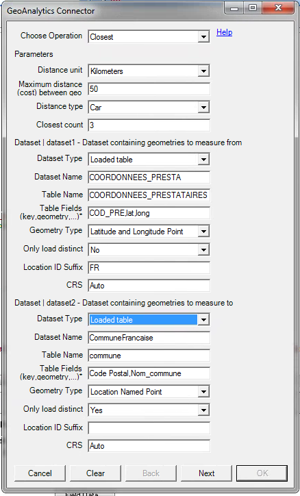
When I place my longitude and latitude data on a QGA map it works fine, but I've the same issue with Closest, the error : Error: Connector reply error: QVX_SYNTAX_ERROR: Failed to process query: Failed to create dataset COORDONNEES_PRESTA: Invalid latitude or longitude value in CSV, [,] is generated.
Best regards,
Mehdi
1,727 Views
Patric_Nordstro
Employee
2020-06-24
09:23 AM
- Mark as New
- Bookmark
- Subscribe
- Mute
- Subscribe to RSS Feed
- Permalink
- Report Inappropriate Content
Can you post a sample of your data?
Thanks,
Patric
1,676 Views
