Unlock a world of possibilities! Login now and discover the exclusive benefits awaiting you.
- Qlik Community
- :
- All Forums
- :
- GeoAnalytics
- :
- Geo Analytics using lat and Longitude
- Subscribe to RSS Feed
- Mark Topic as New
- Mark Topic as Read
- Float this Topic for Current User
- Bookmark
- Subscribe
- Mute
- Printer Friendly Page
- Mark as New
- Bookmark
- Subscribe
- Mute
- Subscribe to RSS Feed
- Permalink
- Report Inappropriate Content
Geo Analytics using lat and Longitude
Hi,
I have a file with Latitude and longitude information but no cities or countries.
How can i use this information to map Idevio Maps(Geo Analytics Extension)
Please Advise.
Accepted Solutions
- Mark as New
- Bookmark
- Subscribe
- Mute
- Subscribe to RSS Feed
- Permalink
- Report Inappropriate Content
Hello Goutham,
Thanks for your question, it depends on the format of the coordinates.
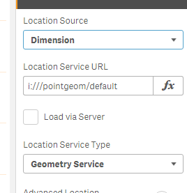
Qlik GeoAnalytics reads them in as Longitude and Latitude and this data can be in different forms. They could be separate columns like Long, Lat - it can be a point such as [Long,Lat]. Geo Analytics gives you a few options for the how you want to define the points in the layers.
I will have a video on this shortly, but please see the attached an example for you.
When you open the app, look at the inline data in the Data Load Editor.
Example 1:
[table1]:
LOAD * Inline "
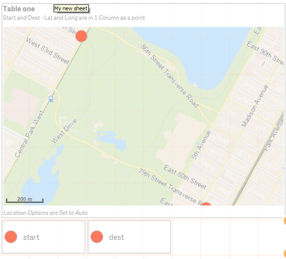
id,start,dest,startname,destname
1,'[-73.969956,40.784690]','[-73.961791,40.776162]',home,gmas
";
Using 2 Bubble Layers - each with one point - and Location options are set to Auto or Dimension:
Example 2:
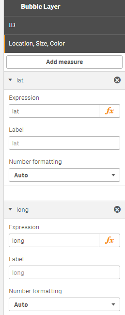
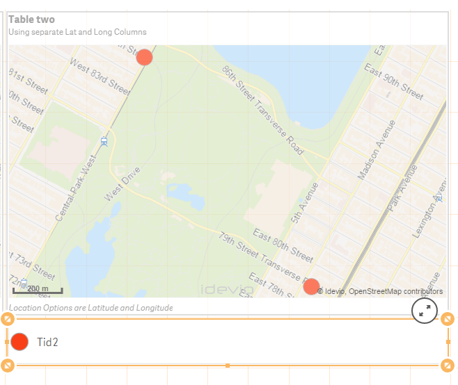
[table2]:
LOAD * Inline "
Tid2,long,lat,name
1,-73.969956,40.784690,start
2,-73.961791,40.776162,end
";
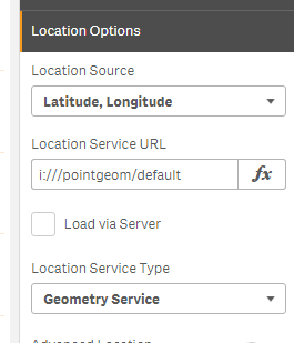
Using one Bubble Layer and setting the Location Options setting to use Latitude,Longitude
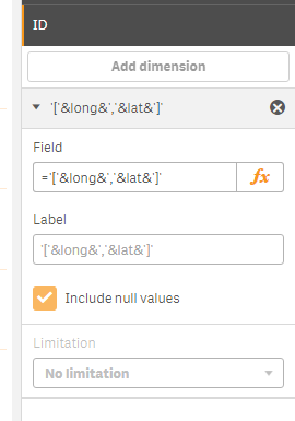
Example 3:
If you have separate Lat and Long like in Table2, you could also create a point coordinate by concatenating the Longitude and Latitude like this ='['&long&','&lat&']' and using it in the dimension of the layer:
Hope this gives you a few key points on how you can use.
See the sample attached.
If using Qlik Sense Desktop please copy .qvf file to your C:\Users\<user profile>\Documents\Qlik\Sense\Apps and refresh Qlik Sense Desktop with F5. If using Qlik Sense Enterprise Server please import .qvf into your apps using the QMC - Qlik Management Console.
When applicable please mark the appropriate replies as CORRECT. This will help community members and Qlik Employees know which discussions have already been addressed and have a possible known solution. Please mark threads as HELPFUL if the provided solution is helpful to the problem, but does not necessarily solve the indicated problem. You can mark multiple threads as HELPFUL if you feel additional info is useful to others.
Regards,
Michael Tarallo (@mtarallo) | Twitter
Qlik
Mike Tarallo
Qlik
- Mark as New
- Bookmark
- Subscribe
- Mute
- Subscribe to RSS Feed
- Permalink
- Report Inappropriate Content
Hello Goutham,
Thanks for your question, it depends on the format of the coordinates.
Qlik GeoAnalytics reads them in as Longitude and Latitude and this data can be in different forms. They could be separate columns like Long, Lat - it can be a point such as [Long,Lat]. Geo Analytics gives you a few options for the how you want to define the points in the layers.
I will have a video on this shortly, but please see the attached an example for you.
When you open the app, look at the inline data in the Data Load Editor.
Example 1:
[table1]:
LOAD * Inline "
id,start,dest,startname,destname
1,'[-73.969956,40.784690]','[-73.961791,40.776162]',home,gmas
";
Using 2 Bubble Layers - each with one point - and Location options are set to Auto or Dimension:
Example 2:
[table2]:
LOAD * Inline "
Tid2,long,lat,name
1,-73.969956,40.784690,start
2,-73.961791,40.776162,end
";
Using one Bubble Layer and setting the Location Options setting to use Latitude,Longitude
Example 3:
If you have separate Lat and Long like in Table2, you could also create a point coordinate by concatenating the Longitude and Latitude like this ='['&long&','&lat&']' and using it in the dimension of the layer:
Hope this gives you a few key points on how you can use.
See the sample attached.
If using Qlik Sense Desktop please copy .qvf file to your C:\Users\<user profile>\Documents\Qlik\Sense\Apps and refresh Qlik Sense Desktop with F5. If using Qlik Sense Enterprise Server please import .qvf into your apps using the QMC - Qlik Management Console.
When applicable please mark the appropriate replies as CORRECT. This will help community members and Qlik Employees know which discussions have already been addressed and have a possible known solution. Please mark threads as HELPFUL if the provided solution is helpful to the problem, but does not necessarily solve the indicated problem. You can mark multiple threads as HELPFUL if you feel additional info is useful to others.
Regards,
Michael Tarallo (@mtarallo) | Twitter
Qlik
Mike Tarallo
Qlik
- Mark as New
- Bookmark
- Subscribe
- Mute
- Subscribe to RSS Feed
- Permalink
- Report Inappropriate Content
Thank you, examples are very helpful
- Mark as New
- Bookmark
- Subscribe
- Mute
- Subscribe to RSS Feed
- Permalink
- Report Inappropriate Content
Awesome - I just published the video as well:
Qlik GeoAnalytics - Latitude and Longitude Tips
Mike Tarallo
Qlik
- Mark as New
- Bookmark
- Subscribe
- Mute
- Subscribe to RSS Feed
- Permalink
- Report Inappropriate Content
Can you use this in an area layer as well?
Thank you for the awesome information.
- Mark as New
- Bookmark
- Subscribe
- Mute
- Subscribe to RSS Feed
- Permalink
- Report Inappropriate Content
Hi Mai - thanks for your question - I am not sure - I will see if bps can assist - are you asking if you can use individual Lat and Long from a data source to create the area layer? - or to plot the points on an area layer as well?
Mike Tarallo
Qlik
- Mark as New
- Bookmark
- Subscribe
- Mute
- Subscribe to RSS Feed
- Permalink
- Report Inappropriate Content
Also I previously used the KML map and area that mapped the zip codes, county and cities in florida perfectly, is there any way I can use the KML area dimension in the area layer to avoid the lookup issues.
Thanks very much.
- Mark as New
- Bookmark
- Subscribe
- Mute
- Subscribe to RSS Feed
- Permalink
- Report Inappropriate Content
Hi Mai,
Yes, you can use the KML areas in the QGA map if you want.
I recommend add the KML area field as the "Location ID" measure.
Thanks,
Patric