Unlock a world of possibilities! Login now and discover the exclusive benefits awaiting you.
- Qlik Community
- :
- All Forums
- :
- GeoAnalytics
- :
- Re: Heat Map on Suburb Level
- Subscribe to RSS Feed
- Mark Topic as New
- Mark Topic as Read
- Float this Topic for Current User
- Bookmark
- Subscribe
- Mute
- Printer Friendly Page
- Mark as New
- Bookmark
- Subscribe
- Mute
- Subscribe to RSS Feed
- Permalink
- Report Inappropriate Content
Heat Map on Suburb Level
Hi There
Im very new to Geoanalytics in qlikview.
I've built a model with a map layer and area chart layer.
When using Province as my dimension in the area layer properties , the heat map renders correctly
When I try using Suburb instead it does not render on the heat map, any suggestions would be appreciated.
Attached is the location settings of my area map which works when using province, when I change to suburb it does not reflect on the map.
- Mark as New
- Bookmark
- Subscribe
- Mute
- Subscribe to RSS Feed
- Permalink
- Report Inappropriate Content
Hi Ridhaa,
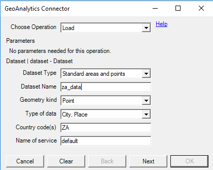
Most likely the suburb names don't get a hit in the location db. Set the map window to show debug info and you can see the mismatches. The internal db for South Africa contains approx 19000 cities and places. You can retrieve the spelling by using the load operation in the QGA connector.
Thanks,
Patric
- Mark as New
- Bookmark
- Subscribe
- Mute
- Subscribe to RSS Feed
- Permalink
- Report Inappropriate Content
Thank you Patric, my issue was that qlik does not have the area geometries for SA , the points are there but not the shapes. I had to bring in shape files via the load connector to resolve
Thank you