Unlock a world of possibilities! Login now and discover the exclusive benefits awaiting you.
- Qlik Community
- :
- All Forums
- :
- GeoAnalytics
- :
- QVX_SYNTAX_ERROR: Failed to process query: Failed ...
- Subscribe to RSS Feed
- Mark Topic as New
- Mark Topic as Read
- Float this Topic for Current User
- Bookmark
- Subscribe
- Mute
- Printer Friendly Page
- Mark as New
- Bookmark
- Subscribe
- Mute
- Subscribe to RSS Feed
- Permalink
- Report Inappropriate Content
QVX_SYNTAX_ERROR: Failed to process query: Failed to create dataset
Hello,
I'm testing the GeoAnalytics connector, I choose TRAVELAREAS function to identify the vendors overlapping areas. Always get this error message:
QVX_SYNTAX_ERROR: Failed to process query: Failed to create dataset AreaCliente: Malformed POINT geometry: -19.3101506.
[TravelAreas]:
SQL SELECT * FROM TravelAreas(dataset='AreaCliente',costValue='2',costField='',costUnit='Hours',transportation='car')
DATASOURCE AreaCliente INLINE tableName='Clientes',tableFields='CHAVE_CLIENTE,LATITUDE,LOGITUDE',geometryType='POINT',loadDistinct='YES',suffix='',crs='Auto' {CHAVE_CLIENTE LATITUDE LOGITUDE
0102205201 -19.3101506 -48.9277299
(...)
0103820901 -19.3101506 -48.9277299}
I check the post QVX_SYNTAX_ERROR Failed to process query Failed to create dataset but its didn´t work for me.
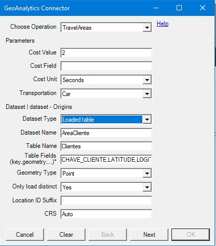
Follow my connection parameters:
Where is the error? Can I fix this?
Tks,
Pedro
- Tags:
- geo analytic
Accepted Solutions
- Mark as New
- Bookmark
- Subscribe
- Mute
- Subscribe to RSS Feed
- Permalink
- Report Inappropriate Content
Hi Pedro,
Choose "Latitude, longitude point" instead of Point.
The geometry type "Latitude, longitude point" is when there are two separate fields for latitude and longitude.
Point is a point string in one field: '[lat, long]'
Thanks,
Patric
- Mark as New
- Bookmark
- Subscribe
- Mute
- Subscribe to RSS Feed
- Permalink
- Report Inappropriate Content
Ok, It´s working now !
Tks a lot !
Pedro
- Mark as New
- Bookmark
- Subscribe
- Mute
- Subscribe to RSS Feed
- Permalink
- Report Inappropriate Content
Hi Pedro almost the same problem hapened with me, but in my table have 2 field for Latitude, longitude, i had choose the option "Latitude, longitude point" and doesnt working
