Unlock a world of possibilities! Login now and discover the exclusive benefits awaiting you.
- Qlik Community
- :
- All Forums
- :
- GeoAnalytics
- :
- Qlik Geo Analytics Connector - Binning
- Subscribe to RSS Feed
- Mark Topic as New
- Mark Topic as Read
- Float this Topic for Current User
- Bookmark
- Subscribe
- Mute
- Printer Friendly Page
- Mark as New
- Bookmark
- Subscribe
- Mute
- Subscribe to RSS Feed
- Permalink
- Report Inappropriate Content
Qlik Geo Analytics Connector - Binning
Hi All,
I am new to Qlik Geo Analytics and recently figured out about Qlik geo connectors.
I am using a sample Excel table for Geo data and connecting to Qlik connector and loaded a auto genrated table [RH0_5W0_75Grid Table].

once the fields are auto generated in the respective table, in the front end which fields should be used to get the Rectangular binning.
Any suggestions please and what is the real use of this connectors? What way it can be utilized?
.Regards,
- Mark as New
- Bookmark
- Subscribe
- Mute
- Subscribe to RSS Feed
- Permalink
- Report Inappropriate Content
Hi,
Binning operation creates an hexagonal or rectangular area layer by clustering points together. Binning is used to group points together, to create a overview layer.
For more info check out the "Binning" examples at
Qlik Sense Guides & Examples « bi.idevio.com and
Guides & Examples « bi.idevio.com
In your example. create an area layer and select "RH0_5W0_75" as the dimension.
Thanks,
Patric
- Mark as New
- Bookmark
- Subscribe
- Mute
- Subscribe to RSS Feed
- Permalink
- Report Inappropriate Content
Hi Patric,
Still, after adding RH_* as a dimension, I am getting an error message as "Error adding Polygon feature".
I am using India states. is it because Indian states are not added still in connector operation?
NOTE : But I am getting Indian state names on normal Area Map. 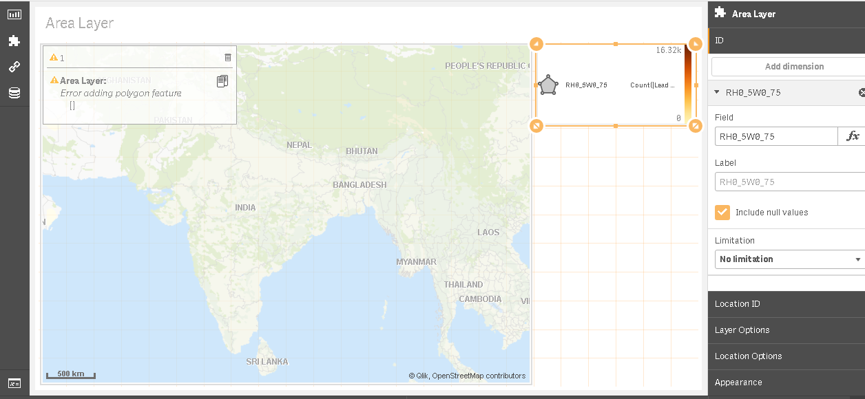
- Mark as New
- Bookmark
- Subscribe
- Mute
- Subscribe to RSS Feed
- Permalink
- Report Inappropriate Content
Hi Patric,
I am using Geo analytics June release, I couldn't able to find the binning operation.
Could you please help me to find in the version I'm using?
Regards,
Mohan
- Mark as New
- Bookmark
- Subscribe
- Mute
- Subscribe to RSS Feed
- Permalink
- Report Inappropriate Content
Hi,
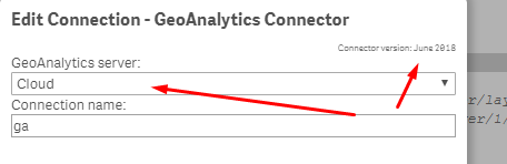
That's strange, the Binning operation should be available in all versions.
The version is visible when making the connection:
Thanks,
Patric
- Mark as New
- Bookmark
- Subscribe
- Mute
- Subscribe to RSS Feed
- Permalink
- Report Inappropriate Content
HI Patric,
Thanks!! I was searching for that in the wrong in place. 
- Mark as New
- Bookmark
- Subscribe
- Mute
- Subscribe to RSS Feed
- Permalink
- Report Inappropriate Content
Hi All - I stumbled across this post and felt my latest blog and video may be helpful to those that stumble across this and may want to see the Binning operation step by step in action:
Get Familiar with Qlik GeoAnalytics - The Binning Operation
Mike Tarallo
Qlik