Unlock a world of possibilities! Login now and discover the exclusive benefits awaiting you.

- Qlik Community
- :
- Forums
- :
- Analytics & AI
- :
- Products & Topics
- :
- Integration, Extension & APIs
- :
- Qlik Sense Heatmaps
- Subscribe to RSS Feed
- Mark Topic as New
- Mark Topic as Read
- Float this Topic for Current User
- Bookmark
- Subscribe
- Mute
- Printer Friendly Page

- Mark as New
- Bookmark
- Subscribe
- Mute
- Subscribe to RSS Feed
- Permalink
- Report Inappropriate Content
Qlik Sense Heatmaps
Hi there,
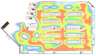
I would like to create a heatmap within Qlik Sense. My requirements:
- Based on X, Y coordinates
- Possible to use my own SVG / PNG. I have a floor plan of a shopping mall either in PNG or SVG I would like to use.
- It should be a separate layer on top of the SVG/PNG, which is not filling predefined SVG / KML areas.
So the result should look something like this:
Thanks!

 simotrab
- Mark as New
- Bookmark
- Subscribe
- Mute
- Subscribe to RSS Feed
- Permalink
- Report Inappropriate Content

 reddy-s
- Mark as New
- Bookmark
- Subscribe
- Mute
- Subscribe to RSS Feed
- Permalink
- Report Inappropriate Content
Hi Jveldhoen,
- Based on X, Y coordinates
- Possible to use my own SVG / PNG. I have a floor plan of a shopping mall either in PNG or SVG I would like to use.
Firstly, convert the PNG image you have into a SVG which can be done using Inkscape. Make use of this generated SVG path and build a visualisation using D3.(This will solve the first two question you have)
Now coming to the third question:
- It should be a separate layer on top of the SVG/PNG, which is not filling predefined SVG / KML areas.
So the result should look something like this:
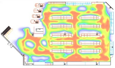
Create an other layer of SVG over the underlying sketch and use fill property to colour this layer , based on your measure or any specific condition.
Hope this helps!
- Sangram
- Mark as New
- Bookmark
- Subscribe
- Mute
- Subscribe to RSS Feed
- Permalink
- Report Inappropriate Content
Hi Sangram,
Thanks for your reply. I already used Inkscape to build a SVG, this works. I also used the SVG Reader (Qlik Sense SVG Reader) to fill the polygons with a colour. But now I want to take it a step further so that I can get gradients of colours like I showed in the picture. You may be right that I need to develop my own D3 extension to do this.
Any other thoughts?
reddy-s
- Mark as New
- Bookmark
- Subscribe
- Mute
- Subscribe to RSS Feed
- Permalink
- Report Inappropriate Content
Hi Jveldhoen,
I think building an extension for this requirement is the best way to go.Let me know if you need any help in building an extension.
Thanks and Regards,
Sangram Reddy.

 konrad_mattheis
- Mark as New
- Bookmark
- Subscribe
- Mute
- Subscribe to RSS Feed
- Permalink
- Report Inappropriate Content
Hi,
you can do this perfect with NPGeoMap (officiall they have only a qlikview extension, but you can already get the sense beta version). There you can even build graphic drill downs,..
bye
Konrad