Unlock a world of possibilities! Login now and discover the exclusive benefits awaiting you.
- Qlik Community
- :
- All Forums
- :
- QlikView App Dev
- :
- Re: issue in getting plots on a google map in qlik...
- Subscribe to RSS Feed
- Mark Topic as New
- Mark Topic as Read
- Float this Topic for Current User
- Bookmark
- Subscribe
- Mute
- Printer Friendly Page
- Mark as New
- Bookmark
- Subscribe
- Mute
- Subscribe to RSS Feed
- Permalink
- Report Inappropriate Content
issue in getting plots on a google map in qlikview
Dear All,
I followed steps from the document "Steps to implement Google map in Qlikview" and BillionRows.com tutorial, to create a map.
I got the below result:

My issues with this scatter chart are as follows:
1. I deal with only EU countries, hence I do not want the other continents to be visible in the map.
2. The plots are visible in the bottom left corner of the map object and unable to plot accurately over the Europe on the map.
Location Data:
I used the coordinates from the file:
https://developers.google.com/public-data/docs/canonical/countries_csv]
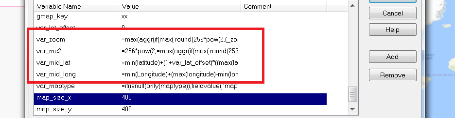
I used map image from the link: ='http://maps.googleapis.com/maps/api/staticmap?center=' & num(var_mid_lat, '##############', '.', ',' ) & ',' & num(var_mid_long, '##############', '.', ',' ) & '&zoom=$(var_zoom)' & '&maptype='&var_maptype & '&size='&map_size_x&'x'&map_size_y & '&sensor=false' & '&scale=&map_scale
My Expressions are as follows:
Longitude: =sum( round (256*pow(2,($(var_zoom)-1)))+( longitude *((256*pow(2,$(var_zoom)))/360)) )
Latitude: =sum(
((256*pow(2,($(var_zoom)-1)))+((0.5*log((1+(sin((latitude)*pi()/180)))/(1-(sin((latitude)*pi()/180)))))*((-256*pow(2,$(var_zoom)))/(2*pi()))))
)
Total Orders created :Count(EU.CUSORD_NO)+Count(EUX.CUSORD_NO)
Axes:
X-axis- Static Min & Static Max:
(256*pow(2,($(var_zoom)-1)))+( var_mid_long *((256*pow(2,$(var_zoom)))/360)) -round(map_size_x/2)
((256*pow(2,($(var_zoom)-1)))+( var_mid_long *((256*pow(2,$(var_zoom)))/360)) + round(map_size_x/2))
Y-axis- Static Min & Static Max:
=((256*pow(2,($(var_zoom)-1)))+((0.5*log((1+(sin(var_mid_lat*pi()/180)))/(1-(sin(var_mid_lat*pi()/180)))))*((-256*pow(2,$(var_zoom)))/(2*pi())))+round(map_size_y/2))
=((256*pow(2,($(var_zoom)-1)))+((0.5*log((1+(sin(var_mid_lat*pi()/180)))/(1-(sin(var_mid_lat*pi()/180)))))*((-256*pow(2,$(var_zoom)))/(2*pi())))-round(map_size_y/2))
How to correct this as per my requirement. Can someone help?
Thank you!
Sai
- Mark as New
- Bookmark
- Subscribe
- Mute
- Subscribe to RSS Feed
- Permalink
- Report Inappropriate Content
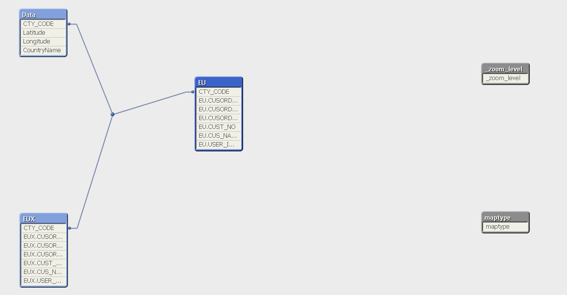
This is my data model. However will validate lats and longs
- Mark as New
- Bookmark
- Subscribe
- Mute
- Subscribe to RSS Feed
- Permalink
- Report Inappropriate Content
can u share your qvw? Maybe with scrambled data?
- Mark as New
- Bookmark
- Subscribe
- Mute
- Subscribe to RSS Feed
- Permalink
- Report Inappropriate Content
Hi Frank attached my QVW hre.
- Mark as New
- Bookmark
- Subscribe
- Mute
- Subscribe to RSS Feed
- Permalink
- Report Inappropriate Content
I found your mistake.
You will have to be careful with the capital letters regarding the fieldnames.
longitude <> Longitude
and
latitude <> Latitude
Qlikview is casesensitive.
I changed it (in the expressions and the in variables) and now it seems to work
- Mark as New
- Bookmark
- Subscribe
- Mute
- Subscribe to RSS Feed
- Permalink
- Report Inappropriate Content
Hi Frank,
Unable to open and started getting this error:


- Mark as New
- Bookmark
- Subscribe
- Mute
- Subscribe to RSS Feed
- Permalink
- Report Inappropriate Content
I assume, Frank just changing the Names only.
longitude <> Longitude
and
latitude <> Latitude
Qlikview is casesensitive.
Can you try same from your application
Note - You don't have license and you are using PE so you exceed number of files opened
- Mark as New
- Bookmark
- Subscribe
- Mute
- Subscribe to RSS Feed
- Permalink
- Report Inappropriate Content
Hi Anil, Can`t I open my own QVW`s as well? 
- Mark as New
- Bookmark
- Subscribe
- Mute
- Subscribe to RSS Feed
- Permalink
- Report Inappropriate Content
Yes just change to capital letters in expression of chart for long and lat
and also in variables:
- Mark as New
- Bookmark
- Subscribe
- Mute
- Subscribe to RSS Feed
- Permalink
- Report Inappropriate Content
you cant open because i saved it and so its no longer your qvw 🙂
- Mark as New
- Bookmark
- Subscribe
- Mute
- Subscribe to RSS Feed
- Permalink
- Report Inappropriate Content
actually I am not able to open my QVW which I was working locally too