Unlock a world of possibilities! Login now and discover the exclusive benefits awaiting you.
- Qlik Community
- :
- All Forums
- :
- QlikView Integrations
- :
- Re: Google Maps - Cluster
- Subscribe to RSS Feed
- Mark Topic as New
- Mark Topic as Read
- Float this Topic for Current User
- Bookmark
- Subscribe
- Mute
- Printer Friendly Page
- Mark as New
- Bookmark
- Subscribe
- Mute
- Subscribe to RSS Feed
- Permalink
- Report Inappropriate Content
Google Maps - Cluster
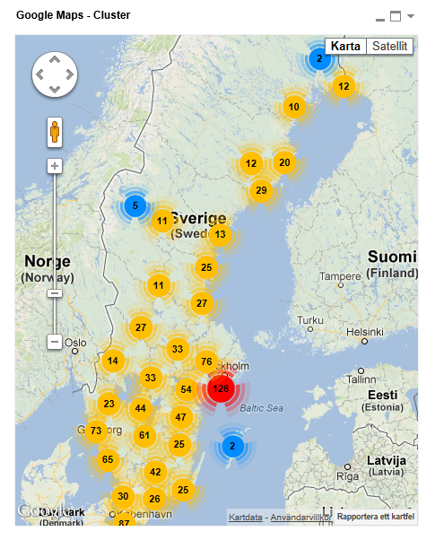
Google Maps Extension with Cluster support.
QlikTech takes no responsibility for any code and QlikTech Support Agreement does not cover issues with this extension.
Please review Googles license agreement before you put this into production.
Introduction
This is a QlikView extension object that integrates Google Maps Javascript API V3 and a third party library called MarkerClusterPlus into QlikView.
Load a set a coordinates into QlikView and visualize them together with this extension. The clustering feature is create when you have alot of data points and needs to group/cluster them together for greater visability and performance.
The maxzoom property defines at what zoom level you want your markers clustered. The grid size property controls how big or small cluster grid size you want.
You can either use the extension 'as is' or use it as a base to further customize it to fit your needs.
Download the extension and view source code at: https://github.com/mindspank/GoogleMaps-Cluster-QV11
If you build something awesome please share it with the community!
Live long and prosper.
2015-02-15
Removed download from post, please grab the latest version from Github instead.
2014-02-03
Various fixes.
2014-01-09
There has been numerous upgrades to the extension.
Now clusters now display the value of your expression and with added support to include more information in pop-up labels.
Example grayscale styled map included.
Possibility to show only a single cluster icon style if you do not want it to scale according to the number of markers in the cluster.
2013-06-17
Added custom marker support. Now you can specify a url for an custom marker. Accepts all major image file types.
- Tags:
- clustering
- extension
- extension_object
- geospatial
- google cluster maps
- google maps
- javascript
- map
- mapping
- qlikview extensions
- qlikview_extensions
- Mark as New
- Bookmark
- Subscribe
- Mute
- Subscribe to RSS Feed
- Permalink
- Report Inappropriate Content
Cool extension, thanks a lot.
Have a quick question - say I have three locations that I want to show on the map, all quite far from each other, and the value involved is just a simple count. I can achieve this easily enough but the icon showing up is the red position marker that shows up on Google maps, but what I'd prefer is the cluster marker that shows up in the original post in this thread, which I would like to colour code depending on the size of the count. If I've explained that clearly, is it possible to do this?
Thanks again for the extension.
- Mark as New
- Bookmark
- Subscribe
- Mute
- Subscribe to RSS Feed
- Permalink
- Report Inappropriate Content
Hi Daniel,
It sounds like you should be using my marker extension instead.
It wont display a number but you can specify custom markers conditional depending on your data.
You can find it at
http://github.com/mindspank
If it still doesn't fit your needs let me know and I can probably whip a custom solution for you.
Kind Regards
Alexander Karlsson
- Mark as New
- Bookmark
- Subscribe
- Mute
- Subscribe to RSS Feed
- Permalink
- Report Inappropriate Content
Morning
I am using the this esxtension which is very cool however my popups are not coming out correctly in the popup contents field I have
'Name - '& [Property Name] & '<br>' & 'Address - '& [Property Street] &', ' & Suburb & ', ' & City & '<br>' & 'Owner - '& [Owner Name] & '<br>' & 'Type - '& [Property Type] & '<br>' & 'Total Area - '& [Area SQM] & ' SQM' & '<br>' & 'Total Rental PA - '& '$'& ([Lease Total Rent PA]+[Lease Opex PA]+[Lease Carpark Rent PA])
But what I am getting on the desktop version is

However once it is on accesspoint what I am getting is

Does anyone have any idea why or what i might be able to do to get the popup message i want
- Mark as New
- Bookmark
- Subscribe
- Mute
- Subscribe to RSS Feed
- Permalink
- Report Inappropriate Content
Hi Alex
I know this has been asked previously but i can't find a response anywhere, does this extension use a free google map key and if so do I need to code one in somewhere?
Thanks for any advice
Bella
- Mark as New
- Bookmark
- Subscribe
- Mute
- Subscribe to RSS Feed
- Permalink
- Report Inappropriate Content
There is no difference in how the Server and Desktop would render the extension.
Are you sure you are using the same version of the extension in both the Desktop and Server?
- Mark as New
- Bookmark
- Subscribe
- Mute
- Subscribe to RSS Feed
- Permalink
- Report Inappropriate Content
Hi,
No Google Maps has stopped using keys altogether so one is not needed.
If you are a current Google Enterprise customer you might want to include your ID and white list the traffic in the Google Management Console but that's about it.
- Mark as New
- Bookmark
- Subscribe
- Mute
- Subscribe to RSS Feed
- Permalink
- Report Inappropriate Content
Thank you for the responses.
I will check the versions of the extension as they may be different.
- Mark as New
- Bookmark
- Subscribe
- Mute
- Subscribe to RSS Feed
- Permalink
- Report Inappropriate Content
I've added,
| Lng | Lat | Desc | Speed Limit |
| -73.987587 | 40.740993 | 1 madison ave | 100 |
| -73.980126 | 40.761697 | 1301 avenue of americas | 200 |
but it shows in balloon symbols instead of circles in yellow color. Can anyone explain me why it shows in that style, why not in circle.
- Mark as New
- Bookmark
- Subscribe
- Mute
- Subscribe to RSS Feed
- Permalink
- Report Inappropriate Content
It will only group markers into clusters if you have more then a number of points within a single area. Try zooming out.
Kind Regards
Alexander Karlsson
- Mark as New
- Bookmark
- Subscribe
- Mute
- Subscribe to RSS Feed
- Permalink
- Report Inappropriate Content
Hi,
I loaded this data,
| Lng | Lat | Desc | Speed Limit |
| -73.987587 | 40.740993 | 1 madison ave | 100 |
| -73.980126 | 40.761697 | 1301 avenue of americas | 200 |
| -74.013487 | 40.711544 | 1 world trade center newyork | 300 |
And I'm getting this output,but I need circles what you can able to do it.
!