Unlock a world of possibilities! Login now and discover the exclusive benefits awaiting you.
- Qlik Community
- :
- All Forums
- :
- QlikView Integrations
- :
- Re: New QlikView Mapping Extensions on QlikMarket
- Subscribe to RSS Feed
- Mark Topic as New
- Mark Topic as Read
- Float this Topic for Current User
- Bookmark
- Subscribe
- Mute
- Printer Friendly Page
- Mark as New
- Bookmark
- Subscribe
- Mute
- Subscribe to RSS Feed
- Permalink
- Report Inappropriate Content
New QlikView Mapping Extensions on QlikMarket
EDIT: These extensions are no longer maintained on QlikMarket since that is not an appropriate place for free and unsupported extensions. I've modified the links below to point to the github repositories where I now keep them. Also, since they're now hosted on github, feel free to make contributions to the code.
Hi everyone,
The demand for mapping in QlikView seems to be a hot topic these days, so I’ve put together two extensions that are now available on QlikMarket bearing the QlikView name.
The first one is an extension which uses SVG images to connect to the data and color and shade the regions in that image:
brianwmunz/svgReader-QV11 · GitHub
Similar to this map of US Counties:
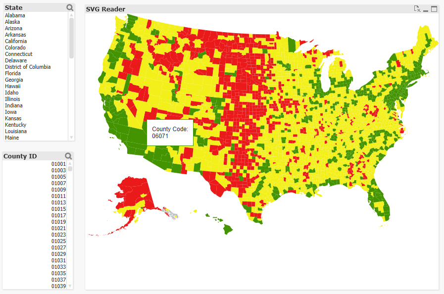
There’s no geospatial connection here (long/lat points can’t be plotted, etc.), but it should prove useful for a lot of simple needs and uses for visualization of a geographical entity. It comes prepackaged with 35 or so maps of countries, etc. and also offers the ability to load in your own custom SVGs for things like floor plans, seating charts, etc.
The second extension is a simple geospatial mapping extension similar to the Google Maps and various other extensions you might have seen in community:
brianwmunz/QuickMap-QV11 · GitHub
This extension simply takes geographic data (longitude/latitude points) from QlikView and draws it over a map. It supports the drawing of dots, lines, or polygon shapes. For example:
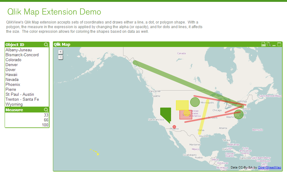
This doesn’t offer near the capabilities of a server based geospatial mapping solution like ESRI, GeoQlik, Idevio, etc. simply because it’s not server side, but it should be helpful for less heavy and complex mapping needs.
Anyway, I hear a lot about need for mapping so I thought I’d let everyone know.
- Mark as New
- Bookmark
- Subscribe
- Mute
- Subscribe to RSS Feed
- Permalink
- Report Inappropriate Content
@Brian Munz i have a problem with my QVW using QlikView Server.
I don´t see my map using browser.
You can help-me?
- Mark as New
- Bookmark
- Subscribe
- Mute
- Subscribe to RSS Feed
- Permalink
- Report Inappropriate Content
After modify many times, i can see map for browser.
I suspect the size map, because, change for 600x600, and nothing filter in customers, the map show me.
And using size 400x400 and nothing filter in customers, don´t see. But, if select some customers, the map is show me.
Thanks for the help.
- Mark as New
- Bookmark
- Subscribe
- Mute
- Subscribe to RSS Feed
- Permalink
- Report Inappropriate Content
We are using Qlikview 11.2 SR6 and Internet Explorer 11, but the quickmap extension works on the desktop but does not on server access point. On server acces point it shows blank as shown in snapshot below.
However another extension Google heatmaps works on access point. Please help.
.png)
- Mark as New
- Bookmark
- Subscribe
- Mute
- Subscribe to RSS Feed
- Permalink
- Report Inappropriate Content
Hey Marc,
I was going through the same exercise you did, looking for this problem, when i found your post. Have you figured a work-around for this? I encountered the same problem and notice that the page map renders fine the first time in qlikview, but navigating back to it, without turning the webview off/on you can't see it. Any thoughts?
Regards,
Saurabh.
- Mark as New
- Bookmark
- Subscribe
- Mute
- Subscribe to RSS Feed
- Permalink
- Report Inappropriate Content
Hi Pramod,
I experienced this as well, see post Quickmap - extension remains blank
It seems that on one server the extension works, installed SR5, and on another server it does not work, SR8. Perhaps the version is the reason?
Did you find any solution?
regards,
Boris
- Mark as New
- Bookmark
- Subscribe
- Mute
- Subscribe to RSS Feed
- Permalink
- Report Inappropriate Content
Thanks Brian the same issue was with me.
- Mark as New
- Bookmark
- Subscribe
- Mute
- Subscribe to RSS Feed
- Permalink
- Report Inappropriate Content
Hi Brian,
Does these map extension(s) work in QliKSense? or is this handled differently in QliKSense.
- Mark as New
- Bookmark
- Subscribe
- Mute
- Subscribe to RSS Feed
- Permalink
- Report Inappropriate Content
Hi Brian,
How can I incorporate this extension in Qlik Sense?
Thanks
- Mark as New
- Bookmark
- Subscribe
- Mute
- Subscribe to RSS Feed
- Permalink
- Report Inappropriate Content
Hi,
Does someone know a documentation or some samples about how to setup drill down in map ?? I mean, a World map displayed at startup and a country map then a country is selected, then a province map when a province is selected ... etc ?? How to change the map regarding selection ?
Many thanks for your help and many thanks to Brian for this great extension !
For information, I'm using Free QlikView Desktop and I can't read any qvw from someone else than mine, except if you open up the content.
Regards,
Gilles
- Mark as New
- Bookmark
- Subscribe
- Mute
- Subscribe to RSS Feed
- Permalink
- Report Inappropriate Content
Hi Brian,
i have your extension quik map downloaded, great! Now, i have a question to it: by the start, it's shows everyone the world in the map. can i zoom it automaticly by the start to a point or a region?