Unlock a world of possibilities! Login now and discover the exclusive benefits awaiting you.
- Qlik Community
- :
- Forums
- :
- Analytics & AI
- :
- Products & Topics
- :
- Visualization and Usability
- :
- Qlik Sense Map Creation
- Subscribe to RSS Feed
- Mark Topic as New
- Mark Topic as Read
- Float this Topic for Current User
- Bookmark
- Subscribe
- Mute
- Printer Friendly Page
- Mark as New
- Bookmark
- Subscribe
- Mute
- Subscribe to RSS Feed
- Permalink
- Report Inappropriate Content
Qlik Sense Map Creation
Hi All,
I have a file which contains the US State names along with various other measures columns. I want to display the States in a map. I am able to create a map by storing latitude and longitude information of all the states in another file and then importing that file into Qlik Sense.
However, my query is can we create a map without separately importing the longitude and latitude information from another file. Is Qlik Sense able to create a map if we have only the State names in a file without longitude and latitude information? If yes. can anyone please let me know how to do that.
Thanks and Regards,
Rajarshi Guin
- « Previous Replies
-
- 1
- 2
- Next Replies »
- Mark as New
- Bookmark
- Subscribe
- Mute
- Subscribe to RSS Feed
- Permalink
- Report Inappropriate Content
Hi,
If you load the table which contains the Departments column with the DATA MANAGER, Qliksense will try to recognize geographical informations for you and creates a geographical field, But I'm not sure that it can recognize departments, it worked for me with country field for example.
Otherwise, use your latitude and longitude informations with GeoMakePoints() to be able to display them on a map.
- Mark as New
- Bookmark
- Subscribe
- Mute
- Subscribe to RSS Feed
- Permalink
- Report Inappropriate Content
Hello,
in my experience when you load a table wich contains cities or states or countries, in the map Qlik Sense gonna recognize but not allow to display as points but it gonna fill all the country for example the value Paris it gonna fill all the France but if you had fields with Longitude and Latitude it gonna just point the city Paris.
and May be i am wrong, wait for our experienced friends answers.
P.S: i was wrong it's possible for cities read below but states no points able just polygone and it's logical
- Mark as New
- Bookmark
- Subscribe
- Mute
- Subscribe to RSS Feed
- Permalink
- Report Inappropriate Content
To be able to use Your states in a Map chart; you have to tell QLIK to help you with that.
Now, with that being said; there is 2 ways of loading data :
1) through the script : We have the full control
2) through the data load editor : Where QLIK SENSE try to assist/help us
So, with that being said; what yoiu should is go to the data load editor ;
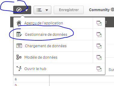
synchronise the table of the script:
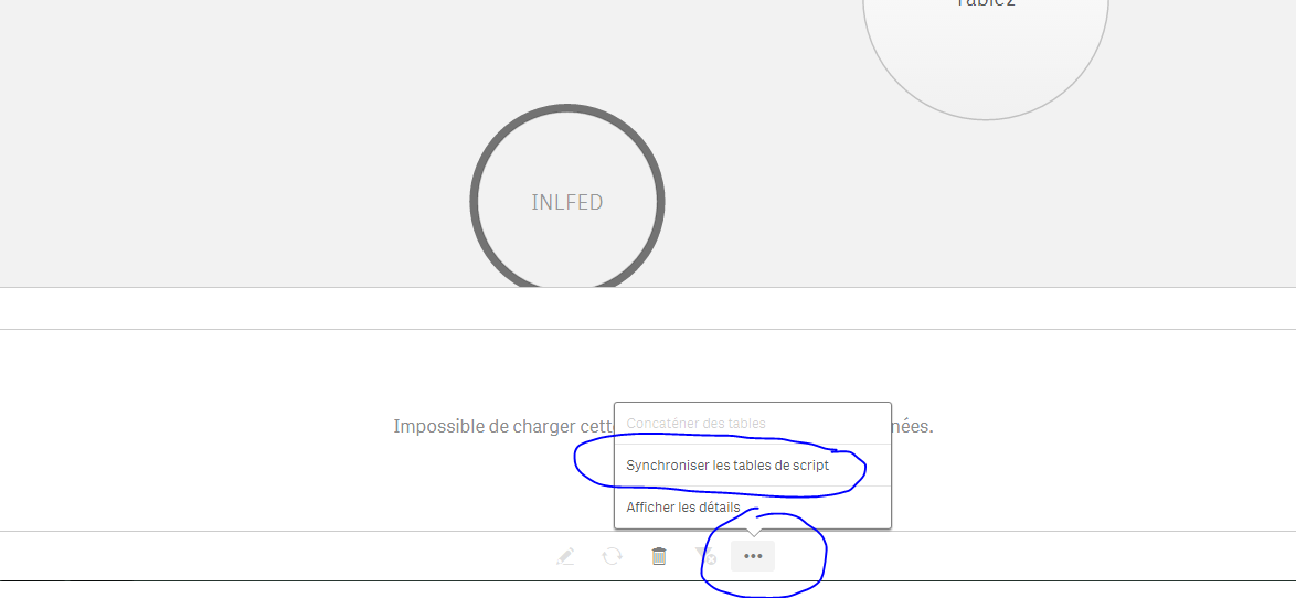
and than reload data.
With that, Qlik SENSE will recognize your states as GeoFields and thus you can use them directly in a map chart without lat/lon combinations.
- Mark as New
- Bookmark
- Subscribe
- Mute
- Subscribe to RSS Feed
- Permalink
- Report Inappropriate Content
As far as I've seen; Qlik Sense (through data load editor) recognizes cities as points and countries as polygonnes
- Mark as New
- Bookmark
- Subscribe
- Mute
- Subscribe to RSS Feed
- Permalink
- Report Inappropriate Content
Hi omarbensalem what do you mean by "tell Qlik to help him with that " ?
- Mark as New
- Bookmark
- Subscribe
- Mute
- Subscribe to RSS Feed
- Permalink
- Report Inappropriate Content
Youssef,
There is 2 ways to load your data in QLIK SENSE
1) script: Qlik does not assist with this; we have full control over everything
2)Data load editor: QLik Sense assist us with this; recognizes GeoFields, Date field, creates auto calendar, time measures (YTD and so on), helps with the table associations , proposes recommandations, concatenations, crossing tables, data fractionning and so on..
So, to be able to use the City Names in a Map object without loading their Lat/Lon, we have to tell QLIK to HELP us with that => Synchronise our table through the data load editor and reload.
And only with this, Qlik will recognize our city names as GeoFields (only by their name, no need to lat/lon) and thus we'll be able to use them in a chart Map.
ps: I was trying to explain this approach rather then telling him directly what to do
- Mark as New
- Bookmark
- Subscribe
- Mute
- Subscribe to RSS Feed
- Permalink
- Report Inappropriate Content
Hello again,
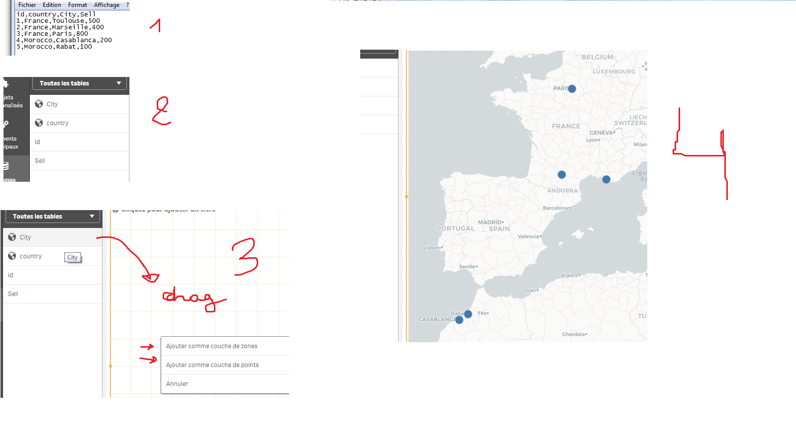
Well as Omar said it worked you have just to write the name of cities in correct format to make Qlik Sense recognize the cities
here is an example of data without longitude and latitude information and i made the points on the map
- Mark as New
- Bookmark
- Subscribe
- Mute
- Subscribe to RSS Feed
- Permalink
- Report Inappropriate Content
Hello Omar i can't use the Synchronise our table , i don't have the hand 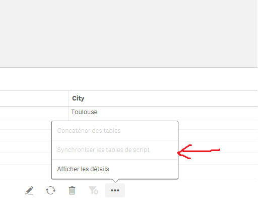
- Mark as New
- Bookmark
- Subscribe
- Mute
- Subscribe to RSS Feed
- Permalink
- Report Inappropriate Content
Have you loaded your data directly through the data load editor? Or through the script?
- « Previous Replies
-
- 1
- 2
- Next Replies »