Unlock a world of possibilities! Login now and discover the exclusive benefits awaiting you.
Announcements
Talend Cloud AWS EU Scheduled Outage: Starting Tues 26 May 21:00 CEST with expected completion Wed 27 May 01:00 CEST
- Qlik Community
- :
- Forums
- :
- Analytics & AI
- :
- Products & Topics
- :
- App Development
- :
- Re: QlikSense 1.1 Master Items and geokey error
Options
- Subscribe to RSS Feed
- Mark Topic as New
- Mark Topic as Read
- Float this Topic for Current User
- Bookmark
- Subscribe
- Mute
- Printer Friendly Page
Turn on suggestions
Auto-suggest helps you quickly narrow down your search results by suggesting possible matches as you type.
Showing results for
Not applicable
2015-02-25
08:23 AM
- Mark as New
- Bookmark
- Subscribe
- Mute
- Subscribe to RSS Feed
- Permalink
- Report Inappropriate Content
QlikSense 1.1 Master Items and geokey error
I tried to create point map and use Geokey (latitude longitude) as a Master Item. When I drag and drop Geokey to Map object it gives me error: "The action you are attempting cannot be applied to this visualization". Anyone know either I do something wrong or has this been changed for somehow or ...?
969 Views
1 Reply
Former Employee
2015-02-25
11:52 AM
- Mark as New
- Bookmark
- Subscribe
- Mute
- Subscribe to RSS Feed
- Permalink
- Report Inappropriate Content
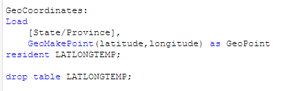
Here is a quick example that uses lat/long of state. There are a lot of field selections but i'm making sure to specifically select the geopoint field i generated in the script. Does this work for you in your app ?
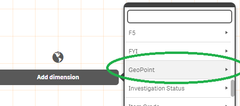
Here i make sure to select the geopoint field:
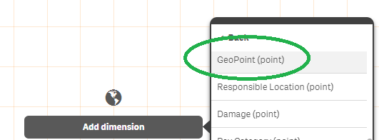
And then the geopoint (point) option in the sub list:
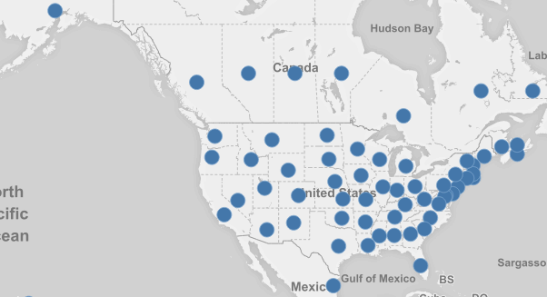
and then we are in business
482 Views