Unlock a world of possibilities! Login now and discover the exclusive benefits awaiting you.
- Qlik Community
- :
- All Forums
- :
- GeoAnalytics
- :
- Export Maps with Mashup
- Subscribe to RSS Feed
- Mark Topic as New
- Mark Topic as Read
- Float this Topic for Current User
- Bookmark
- Subscribe
- Mute
- Printer Friendly Page
- Mark as New
- Bookmark
- Subscribe
- Mute
- Subscribe to RSS Feed
- Permalink
- Report Inappropriate Content
Export Maps with Mashup
Hello!
I am currently searching if there is any way to deal with the GeoAnalytics limitations in terms of exporting / printing.
Do you know if there is any workaround to deal with this?
For those who already develop a mashup having GeoAnalytics maps, is it possible to save the webpage or export it without problems?
BR
Accepted Solutions
- Mark as New
- Bookmark
- Subscribe
- Mute
- Subscribe to RSS Feed
- Permalink
- Report Inappropriate Content
Hi,
Printing is limited in QGA map view, however the new native map chart as of QS April 2018 have full support for printing.
QGA and the native map chart can combined, the native map chart can connect to on-premise QGA server and the output of QGA connector operations can be visualized.
Thanks,
Patric
- Mark as New
- Bookmark
- Subscribe
- Mute
- Subscribe to RSS Feed
- Permalink
- Report Inappropriate Content
Hi @Patric_Nordstrom ,
what about Qlikview 11 and GeoAnalytics-QVD-Extensions-February_2019.
the printing problem for GeoAnalytics was solved or no?
if no, is there any workaround ( except using printing option of browser)?
Thank you in advance.
Regards,
Matsa
- Mark as New
- Bookmark
- Subscribe
- Mute
- Subscribe to RSS Feed
- Permalink
- Report Inappropriate Content
@Matsa Nprinting for QlikView doesn't support extensions, the printing takes place without web view.
Thanks,
Patric
- Mark as New
- Bookmark
- Subscribe
- Mute
- Subscribe to RSS Feed
- Permalink
- Report Inappropriate Content
Thanks @Patric_Nordstrom for the response.
' the printing takes place without web view' Do you mean from Access point can we use printing GeoAnalytic?( because when we print it , we faced with error message):
Thank you in advance.
Regard,
Matsa
- Mark as New
- Bookmark
- Subscribe
- Mute
- Subscribe to RSS Feed
- Permalink
- Report Inappropriate Content
Yes. that is because NPrinting can't print extensions.
Thanks,
Patric
- Mark as New
- Bookmark
- Subscribe
- Mute
- Subscribe to RSS Feed
- Permalink
- Report Inappropriate Content
Hello @Patric_Nordstrom , But I did not use Nprinting !
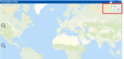
Here are the steps which I did and faced with mentioned error:
- going on access point
- click on 'print ' on top of GeoAnalytics Map
would you please guide me how could I print Geoanalytics?( except using print option of browser)
Thank you in advance.
Matsa
- Mark as New
- Bookmark
- Subscribe
- Mute
- Subscribe to RSS Feed
- Permalink
- Report Inappropriate Content
No, printing using the browser is the only option. Thanks, Patric

