Unlock a world of possibilities! Login now and discover the exclusive benefits awaiting you.
- Qlik Community
- :
- All Forums
- :
- GeoAnalytics
- :
- Re: GeoAnalytics Within problem
- Subscribe to RSS Feed
- Mark Topic as New
- Mark Topic as Read
- Float this Topic for Current User
- Bookmark
- Subscribe
- Mute
- Printer Friendly Page
- Mark as New
- Bookmark
- Subscribe
- Mute
- Subscribe to RSS Feed
- Permalink
- Report Inappropriate Content
GeoAnalytics Within problem
Hello,
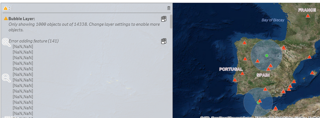
A little insight in the App first, i have a series of points which i have calculated the 200km area around them. Now i addeed another set of points and need to relate the points to the area, so when i am selecting an area only the points within the area show up. So i decided to do a Within function. However it is showing this error:
This are the Within Parameters:
And this is the data model just in case:
Anything i am doing wrong? Can anyone give me any insight?
Thank you very much in advance
Juan Tafarello
Accepted Solutions
- Mark as New
- Bookmark
- Subscribe
- Mute
- Subscribe to RSS Feed
- Permalink
- Report Inappropriate Content
Hi,
Looks ok but the Within operation seems to have the wrong" Geometry type".
The first loaded table should be "Point", if NewCoordenadas looks like '[long,lat]'
Th he second one should be "Polygon" if the TravelAreas looks like '[[[long,lat],[ ....
Thanks,
Patric
- Mark as New
- Bookmark
- Subscribe
- Mute
- Subscribe to RSS Feed
- Permalink
- Report Inappropriate Content
Yes of course !
I would try to load a subset, first ten points to narrow down the problem.
- Mark as New
- Bookmark
- Subscribe
- Mute
- Subscribe to RSS Feed
- Permalink
- Report Inappropriate Content
There is one issue related to reload of 2 map layers. The map appears only the first time when application open. After some filters/clicks it doesn't reload. I have put the condition on both the layers like if type www.walgreenslistens.com
- Mark as New
- Bookmark
- Subscribe
- Mute
- Subscribe to RSS Feed
- Permalink
- Report Inappropriate Content
Hi,
Looks ok but the Within operation seems to have the wrong" Geometry type".
The first loaded table should be "Point", if NewCoordenadas looks like '[long,lat]'
Th he second one should be "Polygon" if the TravelAreas looks like '[[[long,lat],[ ....
Thanks,
Patric
- Mark as New
- Bookmark
- Subscribe
- Mute
- Subscribe to RSS Feed
- Permalink
- Report Inappropriate Content
First of all, thank you for your quick answer Patric. It was interesting and gave me some different approach. So i tried to change the different Geometry types of the operation but i have some errors due to format. First, this is the error that came up with this operator setting:
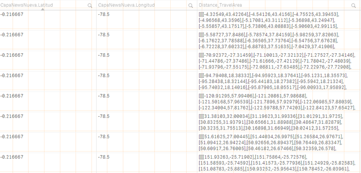
I deduced it might be a problem with my data, so i am showing underneath this some examples of my data to see if you can see any problems here.
Thank you very much for your anwers again, and sorry any incovenience
Juan Tafarello
- Mark as New
- Bookmark
- Subscribe
- Mute
- Subscribe to RSS Feed
- Permalink
- Report Inappropriate Content
The connector is sensitive to bad data so pls check that all of points have proper lat and long values.
-180>lat>180
-90>long>90
Thanks,
Patric
- Mark as New
- Bookmark
- Subscribe
- Mute
- Subscribe to RSS Feed
- Permalink
- Report Inappropriate Content
I am assuming you meant the other way around right? Lat is between -90 and 90 and Long between -180 and 180. I have checked different geolocalization systems and it accepts those values.
I checked and formatted every coordinate to be into range and also to be a number. Still, same error:
Enclosed: Invalid latitude or longitude value in CSV, [,]
Any other ideas?
Tank you again,
Juan
- Mark as New
- Bookmark
- Subscribe
- Mute
- Subscribe to RSS Feed
- Permalink
- Report Inappropriate Content
Yes of course !
I would try to load a subset, first ten points to narrow down the problem.


