Unlock a world of possibilities! Login now and discover the exclusive benefits awaiting you.
- Qlik Community
- :
- All Forums
- :
- GeoAnalytics
- :
- Pins are not coming if plotting pin by name and la...
- Subscribe to RSS Feed
- Mark Topic as New
- Mark Topic as Read
- Float this Topic for Current User
- Bookmark
- Subscribe
- Mute
- Printer Friendly Page
- Mark as New
- Bookmark
- Subscribe
- Mute
- Subscribe to RSS Feed
- Permalink
- Report Inappropriate Content
Pins are not coming if plotting pin by name and lat long together Qlik Sense Geoanalytic.
Hi,
We have some geographic regions as shown below:
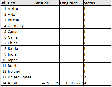
Data load script:
[Geo]:
LOAD
[Id] AS [Geo.Id],
[Geo] AS [GeoName],
[Latitude],
[Longitude],
[Status] AS [Geo.Status],
GeoMakePoint([Latitude], [Longitude]) AS [Longitude_Latitude]
FROM [lib://Desktop/SampleData.xlsx]
(ooxml, embedded labels, table is Geo)
WHERE [Status] = 'A';
I want to plot all these geo's as bubble on map, so to achieve this in bubble layer. I am giving dimension as 'Geo'. Its perfectly working fine for some pins, but for some geo's pins are not plotting like ASGR (Austria, Switzerland,Germany).
So in my Qliksense bubble layer, I have given below expression:
=if(LEN(Longitude_Latitude)>0,Longitude_Latitude,GeoName)
If Longitude_Latitude is not define then plot point based on GeoName else use lat long.
When I am using above expression no bubble is appearing on map, but if am using any of the below given expression then points are showing on map.
Longitude_Latitude //Only ASGR will appear on map
GeoName //Except ASGR all geo will appear on map
So I just wanted to know is there any way through which we can plot these bubble on map by Geo Name and LatLong both?
Thanks
Dilip Solanki
Dilip Solanki
Accepted Solutions
- Mark as New
- Bookmark
- Subscribe
- Mute
- Subscribe to RSS Feed
- Permalink
- Report Inappropriate Content
Hi,
It's not possible to mix geometries and names in the same layer.
However location of different types can be mixed (like country name, state name, city name)
Split up and use two different layers,one for names and one for coordinates.
The USA coordinate is missing a sign, should be -95.7129 in order to be placed correctly
Thanks,
Patric
- Mark as New
- Bookmark
- Subscribe
- Mute
- Subscribe to RSS Feed
- Permalink
- Report Inappropriate Content
Hi,
I have tried one more thing here, am using only lat long now to plot my pin on map.
Have a look in below image, I have used USA lat long but that pin is not even coming on proper place, showing in China somewhere.
USA is showing in China somewhere.
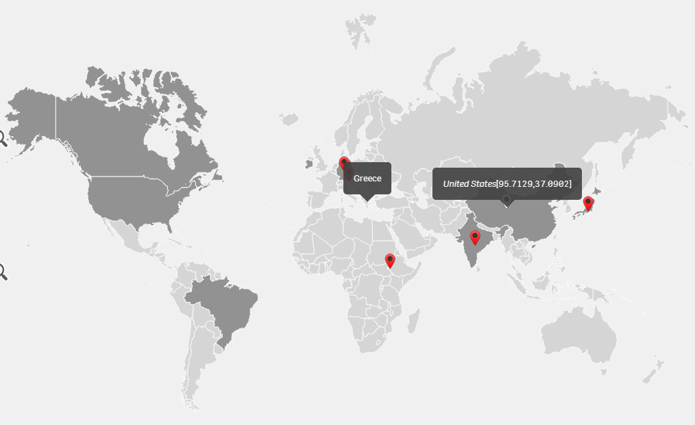
What can be the solution please suggest.
HAPPY NEW YEAR
Thanks
Dilip Solanki
Dilip Solanki
- Mark as New
- Bookmark
- Subscribe
- Mute
- Subscribe to RSS Feed
- Permalink
- Report Inappropriate Content
Hi,
It's not possible to mix geometries and names in the same layer.
However location of different types can be mixed (like country name, state name, city name)
Split up and use two different layers,one for names and one for coordinates.
The USA coordinate is missing a sign, should be -95.7129 in order to be placed correctly
Thanks,
Patric