Unlock a world of possibilities! Login now and discover the exclusive benefits awaiting you.
- Qlik Community
- :
- All Forums
- :
- GeoAnalytics
- :
- Using coordinates on a raster building plan
- Subscribe to RSS Feed
- Mark Topic as New
- Mark Topic as Read
- Float this Topic for Current User
- Bookmark
- Subscribe
- Mute
- Printer Friendly Page
- Mark as New
- Bookmark
- Subscribe
- Mute
- Subscribe to RSS Feed
- Permalink
- Report Inappropriate Content
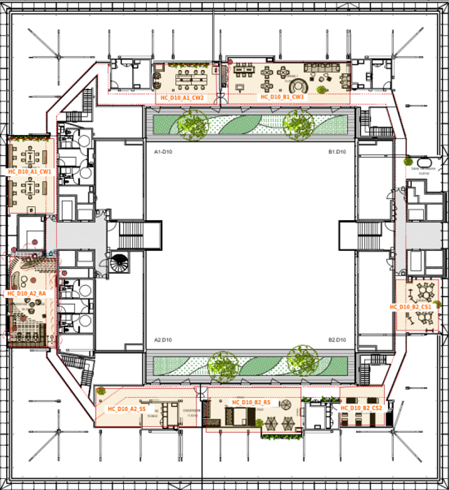
Using coordinates on a raster building plan
Hi everyone,
I'd need help to display plots on building plans.
For instance, on attached file, you have multiple offices, and I'd like my stats to show for my office when I select it.
So, I created an inline table on which I have two fields, the id (e.g. HC_D10_A1_CW1) and the coordonates. The question is : how can I define the coordonates properly ? How can I find the X and the Y info ?
Thanks for helping me.
- Mark as New
- Bookmark
- Subscribe
- Mute
- Subscribe to RSS Feed
- Permalink
- Report Inappropriate Content
Use the image pixels as coordinate system. Note that map origo is bottom left. Most image programs uses top left.
See the example "Map image background" at
If you have several offices, use a field or a variable to toggle between them
load * inline [
office, url
1, https://....
2, https://...
];
Thanks,
Patric