Unlock a world of possibilities! Login now and discover the exclusive benefits awaiting you.
- Qlik Community
- :
- All Forums
- :
- GeoAnalytics
- :
- Re: zip code look up error in qlik geoanalytics
- Subscribe to RSS Feed
- Mark Topic as New
- Mark Topic as Read
- Float this Topic for Current User
- Bookmark
- Subscribe
- Mute
- Printer Friendly Page
- Mark as New
- Bookmark
- Subscribe
- Mute
- Subscribe to RSS Feed
- Permalink
- Report Inappropriate Content
zip code look up error in qlik geoanalytics
Good day,
I am create an area map based on the zip code. I have a spreadsheet in the model that that has the zip code longitude and latitude points, but I still have a few look up errors even though the points are there. Do you know how I can resolve this with or without the connector. I am not sure how to complete the connector fields.
thank you for your help.
- Tags:
- qlik geoanalytics
Accepted Solutions
- Mark as New
- Bookmark
- Subscribe
- Mute
- Subscribe to RSS Feed
- Permalink
- Report Inappropriate Content
Hi,
Yes, if you have the geometry (polygon) as a field, then you can use it as Location field (for mapchart) or add as a measure for the extension.
Best Regads,
Ana Yakushi
Qlik
- Mark as New
- Bookmark
- Subscribe
- Mute
- Subscribe to RSS Feed
- Permalink
- Report Inappropriate Content
Hello,
If you already have latitude and logitude in your dataset, then you can use them directly.
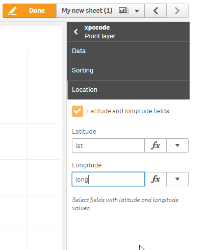
For the mapchart, go to the Point Layer properties, tick the box "Latitude and longitude fields" in the Location tab and input the fields name for latitude and longitude.
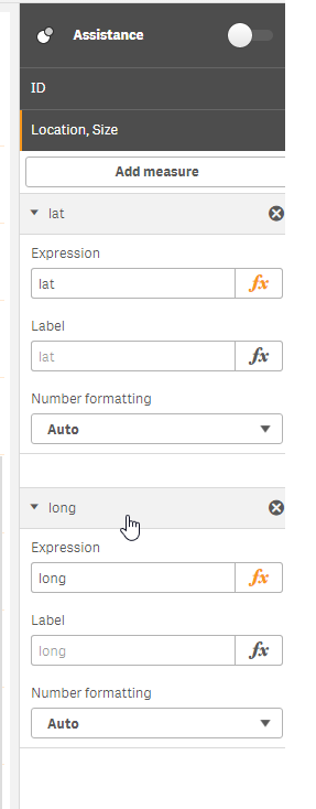
If you are using the extension, go to the Bubble Layer properties and add the latitude and longitude as measures in the "Location, Size" section.
By doing this, the lookup by zip code name will be overridden,
Best Regards,
Ana Yakushi
Qlik
- Mark as New
- Bookmark
- Subscribe
- Mute
- Subscribe to RSS Feed
- Permalink
- Report Inappropriate Content
Thanks so much, does this work completing the same steps with the area layer?
Thanks
- Mark as New
- Bookmark
- Subscribe
- Mute
- Subscribe to RSS Feed
- Permalink
- Report Inappropriate Content
Hi,
Yes, if you have the geometry (polygon) as a field, then you can use it as Location field (for mapchart) or add as a measure for the extension.
Best Regads,
Ana Yakushi
Qlik