Unlock a world of possibilities! Login now and discover the exclusive benefits awaiting you.
- Qlik Community
- :
- Forums
- :
- Analytics & AI
- :
- Products & Topics
- :
- Integration, Extension & APIs
- :
- Re: Qliksense: Map Issue: How can we show differen...
- Subscribe to RSS Feed
- Mark Topic as New
- Mark Topic as Read
- Float this Topic for Current User
- Bookmark
- Subscribe
- Mute
- Printer Friendly Page
- Mark as New
- Bookmark
- Subscribe
- Mute
- Subscribe to RSS Feed
- Permalink
- Report Inappropriate Content
Qliksense: Map Issue: How can we show different images in a map?
RIght now I have checked Map in Qliksense and Google Map Extension.
The Map chart in Qliksense displays only one dimension and one measure. I have attached the QVF file which I have designed.
I need following functionalities in my QVF file:
1) RIght now I have one dimension Location and one measure Count(Vessel Id) . I want to show the Location and the Types of vessels(Vessel Type ID) grounded at that place i.e.
Sandheads
OGV : 1
Transhipper: 2 and so on.
2) Can I show Rectangle, Square,Circle Triangle, Hexagon instead of circle for OGV , Transhipper, Barge, DV and Tug . Some kind of images which can differentiate the types of vessel.
This is an urgent requirement and I am in the middle of this.
jagan reddys310Qlik Sense - Integration, Extensions and APIs
Regards
Rohit
Accepted Solutions
- Mark as New
- Bookmark
- Subscribe
- Mute
- Subscribe to RSS Feed
- Permalink
- Report Inappropriate Content
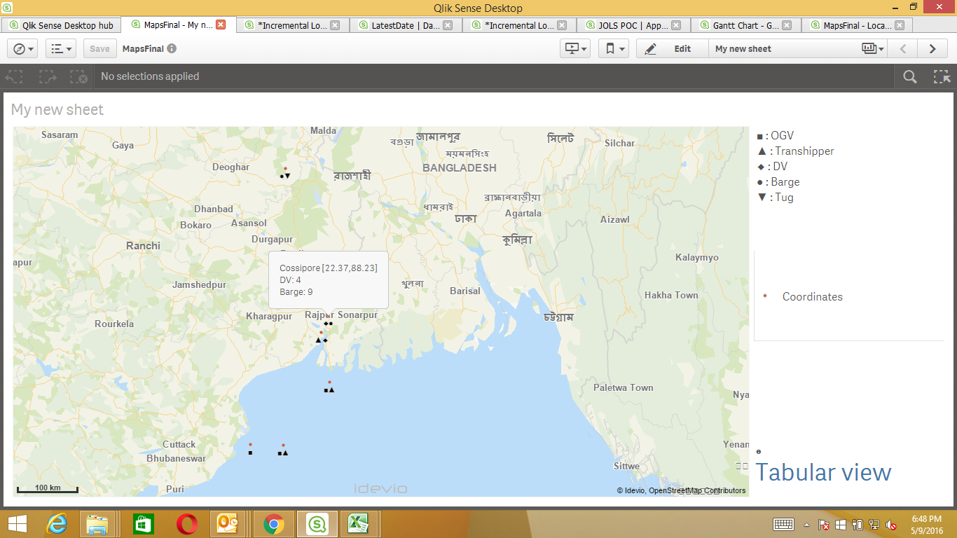
Hi All,
I got test license from Idevio and I have got the desired solution up to a certain extent.
Attached is the image:-
- Mark as New
- Bookmark
- Subscribe
- Mute
- Subscribe to RSS Feed
- Permalink
- Report Inappropriate Content
- Mark as New
- Bookmark
- Subscribe
- Mute
- Subscribe to RSS Feed
- Permalink
- Report Inappropriate Content
I suggest to build an extension using MapBox GL https://www.mapbox.com/mapbox-gl-js/api/
I built one recently to show hexagons on a map.
So, I would say you're rather at a beginning not in the middle of this 😉
- Ralf
- Mark as New
- Bookmark
- Subscribe
- Mute
- Subscribe to RSS Feed
- Permalink
- Report Inappropriate Content
Hi,
Try IdevioMaps (http://bi.idevio.com). It is designed for displaying multiple layers controlled by multiple measures on maps. Contact info@idevio.com to get a test license.
Come see us at Qonnections if you are there.
Regards
Johan
- Mark as New
- Bookmark
- Subscribe
- Mute
- Subscribe to RSS Feed
- Permalink
- Report Inappropriate Content
Sorry, I'm not into Google Maps..
- Mark as New
- Bookmark
- Subscribe
- Mute
- Subscribe to RSS Feed
- Permalink
- Report Inappropriate Content
Hi Manoj,
Yes you will be able to achieve this by using the google Map extension qlikbranch. You will have to enhance this extension to achieve what you are looking for.
- Mark as New
- Bookmark
- Subscribe
- Mute
- Subscribe to RSS Feed
- Permalink
- Report Inappropriate Content
Hi All,
I got test license from Idevio and I have got the desired solution up to a certain extent.
Attached is the image:-