Unlock a world of possibilities! Login now and discover the exclusive benefits awaiting you.
- Qlik Community
- :
- All Forums
- :
- QlikView Integrations
- :
- Re: Geospatial Map Extension for Custom Regions
- Subscribe to RSS Feed
- Mark Topic as New
- Mark Topic as Read
- Float this Topic for Current User
- Bookmark
- Subscribe
- Mute
- Printer Friendly Page
- Mark as New
- Bookmark
- Subscribe
- Mute
- Subscribe to RSS Feed
- Permalink
- Report Inappropriate Content
Geospatial Map Extension for Custom Regions
Hi everyone,
So after releasing the US and Countries Google Map extensions a few days ago, the most common response from people is that it would be great if they could have a map like that for their own country, or for postal codes, or for provinces, or for sales regions, etc. etc.
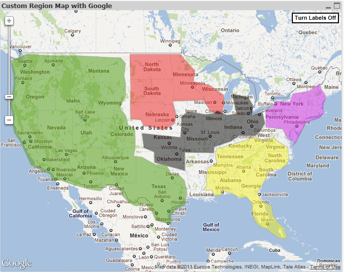
So I made some modifications and created an extension that allows you to define your own custom regions. Here's an (ugly) example:

Rather than posting all of the implementation instructions on here, I created a quick guide on how to get it up and running.
So, while it might be time consuming or require some steps in finding or converting data, you should be able to map whatever regions you want.
Hope this is helpful. I'm working on some non-Google mapping extensions so look for those soon if these extensions are helpful to you.
- Tags:
- extension_object
- extensions
- geographic_chart
- geography
- google_maps
- integration
- javascript
- mapping
- qlikview_extensions
- Mark as New
- Bookmark
- Subscribe
- Mute
- Subscribe to RSS Feed
- Permalink
- Report Inappropriate Content
Hi All,
GIS/Maps Analytics in QlikView is a very interesting topic indeed.
However, there are many technical limitations in using Google Maps (GMaps) to display QlikView KPI indicators. Indeed, the drill-down, pan and selection capabilities are quite limited. Moreover, you cannot display several indicators at the same time and on the same map (background + foreground indicators), you are also limited to draw bubbles and therefore you cannot display pie/bar charts nor "real" heat maps. Finally, you cannot display QlikView KPIs on specific Sales/Business Areas with GMaps such as the Bricks in the Pharmaceutical sector (Brick = aggregation of zipcodes).
On top of that, there are also a few "commercial" aspects to be considered since many QlikView customers & channel partners use GMaps API "FREE" Key inside their QlikView server or rich client without complying with GMaps license terms...Indeed, for "professional internal use" (intranet, extranet or internet with username/password authentication to QlikView application), you must buy GMaps API "Premier" which costs about 10,000 $ USD per year or 8,500 euros per year + possible extra fees depending upon the total number of daily hits.
A few alternatives exist such as Open Street Map (totally FREE) or other WMS/TMS services. I suggest you to have a look at our new mapping extension for QlikView 11 SR1 namely "GeoQlik v11.6":
http://www.geoqlik.com/en/geoqlik-for-qlikview/geoqlik-v11.html
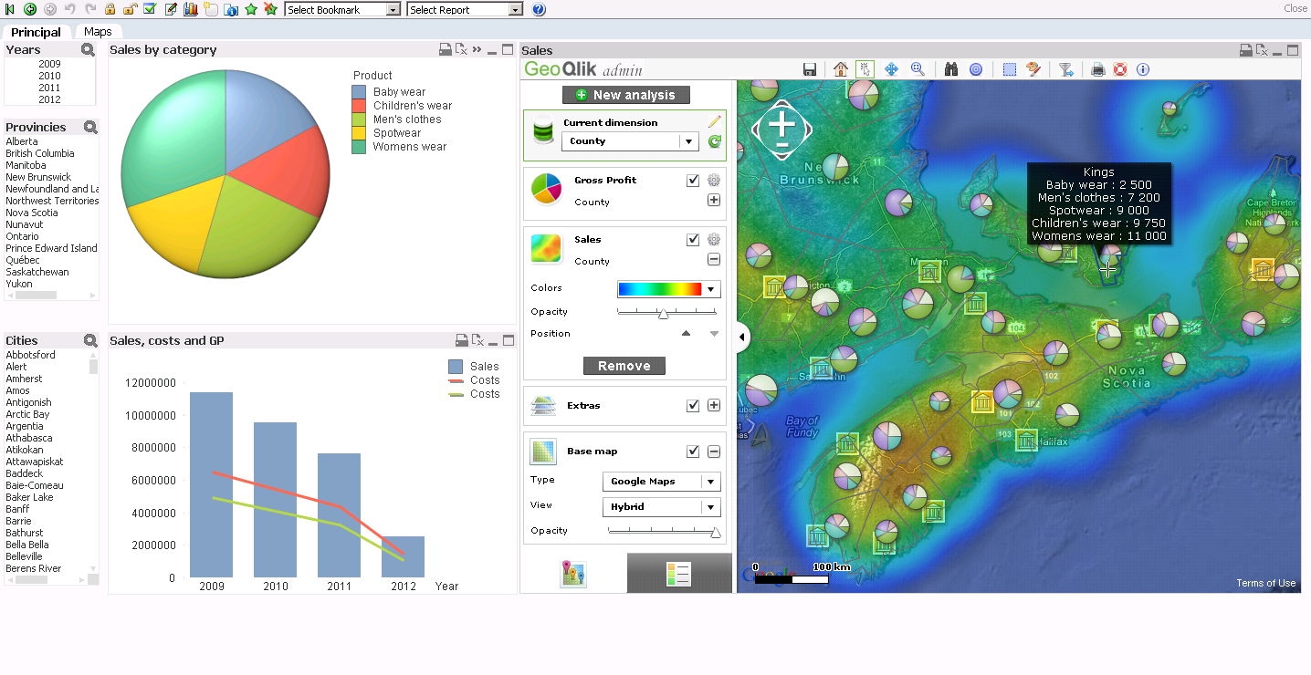
Please find hereafter a few screenshots of GeoQlik V11.6 using WMS/TMS services to display QlikView KPIs:

Thanks and best regards,
David
@ Business Geografic
- Mark as New
- Bookmark
- Subscribe
- Mute
- Subscribe to RSS Feed
- Permalink
- Report Inappropriate Content
Dear, good afternoon.
I am new to extensions, provided you with this, as I have set it to Brazil? Where should I change?
Grateful.
- Mark as New
- Bookmark
- Subscribe
- Mute
- Subscribe to RSS Feed
- Permalink
- Report Inappropriate Content
Brian,
was able to do according to this book teaches the zip file. However when I selected a portion marked, get a pop-up window. You know how it can be done?
- Mark as New
- Bookmark
- Subscribe
- Mute
- Subscribe to RSS Feed
- Permalink
- Report Inappropriate Content
Hello Brian,
Hope you well. Man I found a extension created by you that is very much what I need, the one called "Custom Region Map" very good one.
Man the only thing that is not working is to set the Color. I have 5 Regions and I am trying to set different colors for them, and every time I go to the Color expression, after typing the expression the same one goes blank.
Also if I have not Color Expression the hot color is not working.
Can you advise? I am using QV Desktop Version 11 SR1.
Best regards,
Jorge
- Mark as New
- Bookmark
- Subscribe
- Mute
- Subscribe to RSS Feed
- Permalink
- Report Inappropriate Content
Hello Brian and everyone, great work! I follow the steps to customize Brazil's regions, so I've change regions.js, but isn't work. Check it out:
var cJSON = {};
// The below lines are simply examples of how to format the custom code.
// make sure to put a comma after each region's section (except for the last one)
// Don't forget to put the polyline within the two <br> tags!
cJSON = {
"SP": {
"poly": "<br>ljqiC|yeaIc}uLkybHgho@qqnBeo_AwvfFrig@}~eBff_@ynyCghg@gl}Apf_@gtcAntgDgl}Ah{vB?pteEsia@hdfAgl}Aoln@{v_C}lv@cldE|lv@sa{@ve~@rqGrxmApqnBfdn@znyCrpV|flAnoeAddwBxz{BlaiGtlu@pa{@?h|i@kxlAria@gl}@ddwBuh|Btia@g`uBf|i@u~mApihCe|FxnyCot^dldEl|Fpa{@hqf@|nr@iqYndSk|FrmTwpn@ghjB<br>",
"label": "POKPKMMOMKMOJMPMNBLKLLPMMJOMKMLMJNP"
},
"east": {
"poly": "<br>akm_GnwsjNf~jLidPbfm@w{lPteoF{nyCx~oAcd~ExttChtcAcfeBe|pC_}fOuvmIivy@oabDq{lAu~sHmplB{nyCo_eCh|i@g_wB_wX{djA}nr@iauBuqGk_wDdtjDq~kBtqGpj{DfyiK|l|@lv{OxxeE|~eBc`Xzs_NbjoDdl}A|be@x~lEjnXria@<br>",
"label":"PPONOPMOKMPMLLPMPNOONNKP"
"blank": {
"poly":"<br><br>",
"label":""
}
}
When I reloaded my QVW, just appear the "east" region. Even I put "SP" like a value in dimension "Estado". Could you help me to fix this ?
Regards.
- Mark as New
- Bookmark
- Subscribe
- Mute
- Subscribe to RSS Feed
- Permalink
- Report Inappropriate Content
Hi, I'm not able to use the color expression to configure the custom map. Has anybody an example which really works? I tried an If then else expression - but it doesn't work.
- Mark as New
- Bookmark
- Subscribe
- Mute
- Subscribe to RSS Feed
- Permalink
- Report Inappropriate Content
Hi I probably have a silly question In chart properties, how do I get the Region name in ? the field is not active What have I missed in the instruction
- Mark as New
- Bookmark
- Subscribe
- Mute
- Subscribe to RSS Feed
- Permalink
- Report Inappropriate Content
Hi Brian,
http://gmapspolytool.gmapify.fr/ link is not working,I am getting error
Forbidden
You don't have permission to access / on this server.
any alternate tool for draw own region polyline.
Regards,
Perumal A
- Mark as New
- Bookmark
- Subscribe
- Mute
- Subscribe to RSS Feed
- Permalink
- Report Inappropriate Content
Brian
i just downloaded the extension and found the region details are loading from the called us states.xls. i could not able to find in the extension folder. would like to know the file structure ie Data file.
Thanks you
Srini
- Mark as New
- Bookmark
- Subscribe
- Mute
- Subscribe to RSS Feed
- Permalink
- Report Inappropriate Content
I think the xml I used can be found here: