Unlock a world of possibilities! Login now and discover the exclusive benefits awaiting you.
- Qlik Community
- :
- All Forums
- :
- GeoAnalytics
- :
- Geo Drill down feature in QlikCloud has a minor ca...
- Subscribe to RSS Feed
- Mark Topic as New
- Mark Topic as Read
- Float this Topic for Current User
- Bookmark
- Subscribe
- Mute
- Printer Friendly Page
- Mark as New
- Bookmark
- Subscribe
- Mute
- Subscribe to RSS Feed
- Permalink
- Report Inappropriate Content
Geo Drill down feature in QlikCloud has a minor caveat.....
Patric,
The Drill down feature in QS Maps works but only a "single selection" has to be made. For e.g. Imagine I have a map of 50 States and I have an area layer for states and density layer for cities and that the layers have been configured in a drill down fashion. If I select California, I'll be able to see the underlying density but If I select more than 1 state, i.e. California and Nevada , I'm not able to see the density layer at all.
bps
Accepted Solutions
- Mark as New
- Bookmark
- Subscribe
- Mute
- Subscribe to RSS Feed
- Permalink
- Report Inappropriate Content
Hi Vishnu,
A drill down group works in that way. Tf more than one state is selected the group delivers states.
If one state is selected then the group expands and delivers cities. Try this with filterpane or a table and the drill down group as dimension.
To change, remove the drill down group as the dimension in the density layer. Use city as the dimension.
Now the density layer will be visible all the time, calculation conditions can be used to limit, for instance count(distinct total state)<3 to show the layer with 1 or 2 states selected.
Thanks,
Patric
- Mark as New
- Bookmark
- Subscribe
- Mute
- Subscribe to RSS Feed
- Permalink
- Report Inappropriate Content
Hi Vishnu,
If you don't want to have the Density layer as a drill down, then choose City as the dimension for that layer.
The drill down support is very flexible, choose whether the drill down layer should consist of a single layer or multiple layer. And if the location info should be in the dimension or the measure, here's the pros and cons:
Single layer, drill down group as dimension
Quick to setup but requires location info not to be ambiguous in the drill down group
Single layer, location in the location measure
Simple, suitable for adding location info when the drill down group is not enough.
Multi layer, drill down group as dimension
Full control of layer appearance, can have different layer types per level, but requires location info not to be ambiguous in the drill down group
Multi layer, with calculation conditions
Same as to the left but suitable for adding location info when the drill down group is not enough.
Thanks,
Patric
- Mark as New
- Bookmark
- Subscribe
- Mute
- Subscribe to RSS Feed
- Permalink
- Report Inappropriate Content
- Mark as New
- Bookmark
- Subscribe
- Mute
- Subscribe to RSS Feed
- Permalink
- Report Inappropriate Content
bps
Thanks for the response. My question is, simply:
Say I have an area layer with the 50 states on top and I have a density layer below as a drill down.
When I select a 2 states (Say Nevada and California) - I don't see the density layer at all.
However,
When I select only one state, I see the density layer.
Are there any limitations in the drill down that allow only a single selection of a US State?
Here's the above issue in pictures:
1. Map of the US with an Area layer above and density layer below as drill down
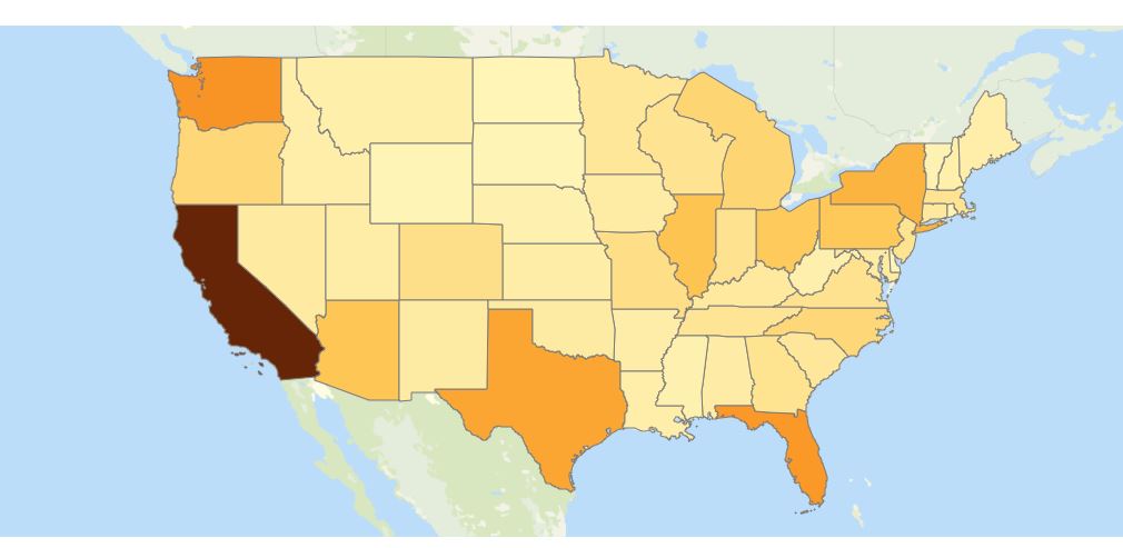
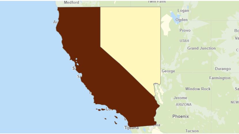
2. Made a selection on 2 states
The density layer should have come up automatically but it didn't.
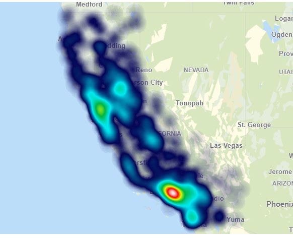
3. So I make a single selection (i.e. I only select California)

4. Now, I see the Density Layer.
I want to see the Density Layer for both California and Nevada.
How do I do that?
Sorry for the re-ask but I couldn't follow your answer.
- Mark as New
- Bookmark
- Subscribe
- Mute
- Subscribe to RSS Feed
- Permalink
- Report Inappropriate Content
Hi Vishnu,
A drill down group works in that way. Tf more than one state is selected the group delivers states.
If one state is selected then the group expands and delivers cities. Try this with filterpane or a table and the drill down group as dimension.
To change, remove the drill down group as the dimension in the density layer. Use city as the dimension.
Now the density layer will be visible all the time, calculation conditions can be used to limit, for instance count(distinct total state)<3 to show the layer with 1 or 2 states selected.
Thanks,
Patric