Unlock a world of possibilities! Login now and discover the exclusive benefits awaiting you.
- Qlik Community
- :
- All Forums
- :
- GeoAnalytics
- :
- 'Sao Paulo' pin is showing in water whereas in goo...
- Subscribe to RSS Feed
- Mark Topic as New
- Mark Topic as Read
- Float this Topic for Current User
- Bookmark
- Subscribe
- Mute
- Printer Friendly Page
- Mark as New
- Bookmark
- Subscribe
- Mute
- Subscribe to RSS Feed
- Permalink
- Report Inappropriate Content
'Sao Paulo' pin is showing in water whereas in google map it is appearing properly : Qlik Sense + Geoanalytic
Hi All,
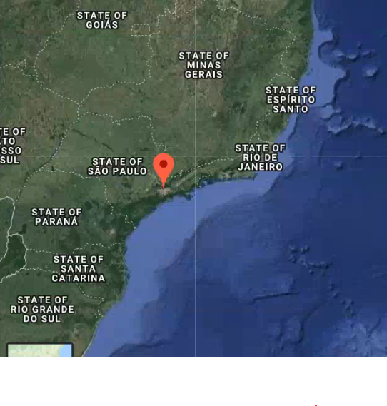
We are using Qlik Sense + Geo analytic, we are facing one issue with pin plotting on map. e.g. We have a city 'Sao Paulo' which in plotting on ocean somewhere in Qlik map but in google map same city is appearing properly (not in water).
We are plotting city pins by city name, not by lat long.
Please find the screen shot of city plotting comparison:
In Qlik map:
In Google map:
Image1
Image2

Same issue we are facing with many other cities like Lisbon, Sau paulo etc.
Please suggest how can we resolve this issue.
Thanks
Dilip Solanki
Dilip Solanki
- « Previous Replies
-
- 1
- 2
- Next Replies »
- Mark as New
- Bookmark
- Subscribe
- Mute
- Subscribe to RSS Feed
- Permalink
- Report Inappropriate Content
Hi,
We are not using longitude and latitude to plot city pins on map. We are using City Name + Country Name. If we place sao paulo with lat long then, I think we need to plot all over maps
pin through lat long.
Can you suggest if is there any way through which we can mix the pin plotting with city + country and lat-long?
How can i use lat-long to plot city pins on map? I am using bubble layer expression to plot pins.
Thanks
Dilip Solanki
Dilip Solanki
- Mark as New
- Bookmark
- Subscribe
- Mute
- Subscribe to RSS Feed
- Permalink
- Report Inappropriate Content
I don't think you can mix.. but you can generate very quickly (coordinates) for your Geo-table and you will have pixel precision on your locations.
- Mark as New
- Bookmark
- Subscribe
- Mute
- Subscribe to RSS Feed
- Permalink
- Report Inappropriate Content
Hi Patric,
Thank you very much. I have changed image size from 24X24 to 24X48. Its working for us now.
Please find the SS of updated pins location:
All red marked pins are coming in exact place (not in water).
Regards,
Dilip Solanki
Dilip Solanki
- Mark as New
- Bookmark
- Subscribe
- Mute
- Subscribe to RSS Feed
- Permalink
- Report Inappropriate Content
Hi Youssef,
Thanks for giving your suggestions, finally I got the solution. Please find my solution below.
Thanks
Dilip Solanki
Dilip Solanki
- « Previous Replies
-
- 1
- 2
- Next Replies »