Unlock a world of possibilities! Login now and discover the exclusive benefits awaiting you.
- Qlik Community
- :
- All Forums
- :
- GeoAnalytics
- :
- Re: Show Origin and Destination Country on Map wit...
- Subscribe to RSS Feed
- Mark Topic as New
- Mark Topic as Read
- Float this Topic for Current User
- Bookmark
- Subscribe
- Mute
- Printer Friendly Page
- Mark as New
- Bookmark
- Subscribe
- Mute
- Subscribe to RSS Feed
- Permalink
- Report Inappropriate Content
Show Origin and Destination Country on Map with Arrows
Hello,
Hope all is well with everyone.
We have a scenario in which we would like to show Origin and Destination Countries linked through a line, having arrows.
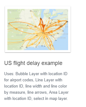
For example how many shipments from one origin (city) to multiple destinations (countries). We downloaded the flight delay example from the geo analytics and tried to modify it but could not. The flight delay is linked with Airport Codes.
We modified the ORIGIN and DESTINATION and made Geo Keys with Location but could not achieve it.
Will appreciate if someone could assist us.
Thanks.
- Mark as New
- Bookmark
- Subscribe
- Mute
- Subscribe to RSS Feed
- Permalink
- Report Inappropriate Content
Hello Syed - thanks for your question. Although you may get a more detailed reply from another member - I am working on a video with this exact scenario as part of this series
Qlik Geocoding - Street Addresses and Qlik GeoAnalytics
Part 2 will show how to use the Closest operator that is part of the Qlik GeoAnalytics connector.
I hope to have this available by end of day today and will update this post with the video when complete.
When applicable please mark the appropriate replies as CORRECT. This will help community members and Qlik Employees know which discussions have already been addressed and have a possible known solution. Please mark threads as HELPFUL if the provided solution is helpful to the problem, but does not necessarily solve the indicated problem. You can mark multiple threads as HELPFUL if you feel additional info is useful to others.
Regards,
Qlik
Mike Tarallo
Qlik
- Mark as New
- Bookmark
- Subscribe
- Mute
- Subscribe to RSS Feed
- Permalink
- Report Inappropriate Content
Dear Michael,
Glad to receive your response.
I think the closest operation is for a different purpose.
We have used the closest operator with one of our telecom customers. They wanted to find out the radius/distance of shops with cellular towers. The closest operator worked very well.
I believe for the our current purpose of showing arrows and lines between the Origin Country and destination city for the shipment will be a different use case. We were following the flight delay example for this case.
Thanks and looking forward in viewing your video. Please do send the link on this post with the video.
Sincerely,
Syed Jawwad Hussain
- Mark as New
- Bookmark
- Subscribe
- Mute
- Subscribe to RSS Feed
- Permalink
- Report Inappropriate Content
Hi,
Just replace the From and To with the location id you want to use, be coordinates or placenames.
Here's another example
Thanks,
Patric
- Mark as New
- Bookmark
- Subscribe
- Mute
- Subscribe to RSS Feed
- Permalink
- Report Inappropriate Content
Ah correct - that is to get route information, I'm still learning myself - lol , I see Patric has replied as well so I know we are in good hands now. 🙂
Mike Tarallo
Qlik