Unlock a world of possibilities! Login now and discover the exclusive benefits awaiting you.
- Qlik Community
- :
- All Forums
- :
- QlikView Integrations
- :
- Re: New QlikView Mapping Extensions on QlikMarket
- Subscribe to RSS Feed
- Mark Topic as New
- Mark Topic as Read
- Float this Topic for Current User
- Bookmark
- Subscribe
- Mute
- Printer Friendly Page
- Mark as New
- Bookmark
- Subscribe
- Mute
- Subscribe to RSS Feed
- Permalink
- Report Inappropriate Content
New QlikView Mapping Extensions on QlikMarket
EDIT: These extensions are no longer maintained on QlikMarket since that is not an appropriate place for free and unsupported extensions. I've modified the links below to point to the github repositories where I now keep them. Also, since they're now hosted on github, feel free to make contributions to the code.
Hi everyone,
The demand for mapping in QlikView seems to be a hot topic these days, so I’ve put together two extensions that are now available on QlikMarket bearing the QlikView name.
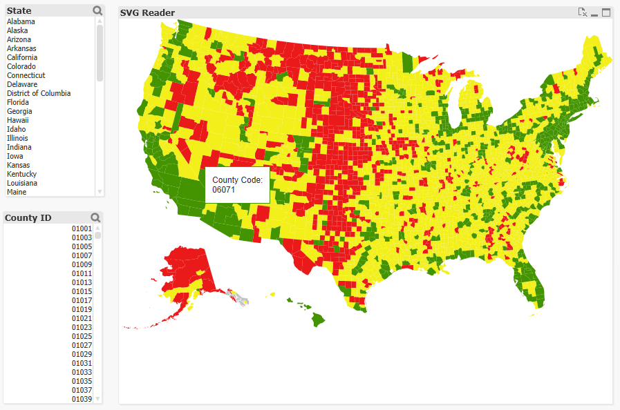
The first one is an extension which uses SVG images to connect to the data and color and shade the regions in that image:
brianwmunz/svgReader-QV11 · GitHub
Similar to this map of US Counties:

There’s no geospatial connection here (long/lat points can’t be plotted, etc.), but it should prove useful for a lot of simple needs and uses for visualization of a geographical entity. It comes prepackaged with 35 or so maps of countries, etc. and also offers the ability to load in your own custom SVGs for things like floor plans, seating charts, etc.
The second extension is a simple geospatial mapping extension similar to the Google Maps and various other extensions you might have seen in community:
brianwmunz/QuickMap-QV11 · GitHub
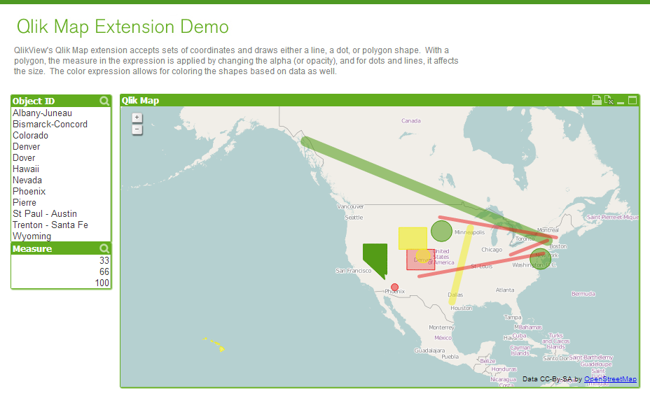
This extension simply takes geographic data (longitude/latitude points) from QlikView and draws it over a map. It supports the drawing of dots, lines, or polygon shapes. For example:

This doesn’t offer near the capabilities of a server based geospatial mapping solution like ESRI, GeoQlik, Idevio, etc. simply because it’s not server side, but it should be helpful for less heavy and complex mapping needs.
Anyway, I hear a lot about need for mapping so I thought I’d let everyone know.
- Mark as New
- Bookmark
- Subscribe
- Mute
- Subscribe to RSS Feed
- Permalink
- Report Inappropriate Content
First of all, big thanks to Brian, I love this extension.
I just wondered if there was some way to make the text in the popup contents span across multiple lines. I have tried using chr(13) and chr(10) in the expression but neither of those appears to be working. Is there a method I am unfamiliar with?
Thanks in advance.
- Mark as New
- Bookmark
- Subscribe
- Mute
- Subscribe to RSS Feed
- Permalink
- Report Inappropriate Content
Hi Noel,
you can use '<br />' for line break..
- Ralf
- Mark as New
- Bookmark
- Subscribe
- Mute
- Subscribe to RSS Feed
- Permalink
- Report Inappropriate Content
Thanks, Ralf, that did the trick. I take it that any other text formatting should be done with html tags then?
- Mark as New
- Bookmark
- Subscribe
- Mute
- Subscribe to RSS Feed
- Permalink
- Report Inappropriate Content
Just try it..
- Mark as New
- Bookmark
- Subscribe
- Mute
- Subscribe to RSS Feed
- Permalink
- Report Inappropriate Content
Hi Brian,
First of all tons of thanks for the extension object (Map) that you created, it saves lot of qlikviewers ![]()
I saw that you have included most of the imp maps and for USA we have US Map & US County, just wondering, is it possible to create one for US DMA level.
Please Advise!
Thanks,
Sri
- Mark as New
- Bookmark
- Subscribe
- Mute
- Subscribe to RSS Feed
- Permalink
- Report Inappropriate Content
Brian,
Many thanks for the mapping extension. Excellent option for mapping in QlikView!
Is there a way to alter the positioning of the zoomed map to not align to the top, left, and bottom window borders? I would like to pad each of those borders for a more centered alignment.
Thanks,
Ron
- Mark as New
- Bookmark
- Subscribe
- Mute
- Subscribe to RSS Feed
- Permalink
- Report Inappropriate Content
Hi Ivan,
could you please also send me an example. I am also looking for something similar. Thank you in advanc ![]()
My email is as followed: usama--@hotmail.de
Regards
- Mark as New
- Bookmark
- Subscribe
- Mute
- Subscribe to RSS Feed
- Permalink
- Report Inappropriate Content
I am having so many issues with the lastest version. I have tried older versions and still have issues. On older dashboards I have not encountered issues. Here is what I am seeing:
If I have an alternate state and two maps, clicking in one causes the other one to lose states. The more I click, the more states that disappear. This even happens with a single map. Even with a single map, it isnt zooming in like i selected and just makes states disappear.
The map always corrects itself after an F5, but as of today nothing is working and I have to F5 after any selection. It isnt zooming or anything. At least on my installation, the SVG map is broken except for the simplest of dashboards.
I am going to be developing my own D3 SVG map in the next few days to overcome this, but this isnt an ideal solution when this is such a widely used extension.
- Mark as New
- Bookmark
- Subscribe
- Mute
- Subscribe to RSS Feed
- Permalink
- Report Inappropriate Content
I believe this bug was fixed in the latest version available on GitHub. At
least those issued went away for us after moving to that latest version.
- Mark as New
- Bookmark
- Subscribe
- Mute
- Subscribe to RSS Feed
- Permalink
- Report Inappropriate Content
Brain
Just want to know , this example will work only when we have internet and have access to google ? Kindly share the info.
Thx