Unlock a world of possibilities! Login now and discover the exclusive benefits awaiting you.
- Qlik Community
- :
- All Forums
- :
- GeoAnalytics
- :
- Re: EU as a single area in Qlik Geo Analytics
- Subscribe to RSS Feed
- Mark Topic as New
- Mark Topic as Read
- Float this Topic for Current User
- Bookmark
- Subscribe
- Mute
- Printer Friendly Page
- Mark as New
- Bookmark
- Subscribe
- Mute
- Subscribe to RSS Feed
- Permalink
- Report Inappropriate Content
EU as a single area in Qlik Geo Analytics
Hello community,
I was wondering whether there is a way to perform the European Union as single area using the Area Layer in Qlik Geo Analytics?
Any hint is very much appreciated.
Denis
Accepted Solutions
- Mark as New
- Bookmark
- Subscribe
- Mute
- Subscribe to RSS Feed
- Permalink
- Report Inappropriate Content
Hi Denis,
Yes you can easily create a custom region using the Location Named Areas from a predefined table with countries. Please note that you don't need the geometries for the countries, just the names.
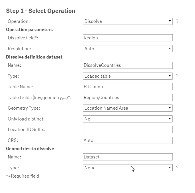
As an example I created an Excel file with the 28 EU countries and run the Dissolve operation with the following parameters.
Maybe you would like to create a drill down from EU to country with a master item Region to Country as well. This can then be added as an area layer and you can be clicking on a country zoom into the chosen country.
Table of Countries and Region:
| Countries | Region |
| Austria | EU |
| Belgium | EU |
| Bulgaria | EU |
| Croatia | EU |
| Cyprus | EU |
| Czech Republic | EU |
| Denmark | EU |
| Estonia | EU |
| Finland | EU |
| France | EU |
| Germany | EU |
| Greece | EU |
| Hungary | EU |
| Ireland | EU |
| Italy | EU |
| Latvia | EU |
| Lithuania | EU |
| Luxembourg | EU |
| Malta | EU |
| Netherlands | EU |
| Poland | EU |
| Portugal | EU |
| Romania | EU |
| Slovakia | EU |
| Slovenia | EU |
| Spain | EU |
| Sweden | EU |
| United Kingdom | EU |
- Mark as New
- Bookmark
- Subscribe
- Mute
- Subscribe to RSS Feed
- Permalink
- Report Inappropriate Content
Hi Denis,
Yes you can easily create a custom region using the Location Named Areas from a predefined table with countries. Please note that you don't need the geometries for the countries, just the names.
As an example I created an Excel file with the 28 EU countries and run the Dissolve operation with the following parameters.
Maybe you would like to create a drill down from EU to country with a master item Region to Country as well. This can then be added as an area layer and you can be clicking on a country zoom into the chosen country.
Table of Countries and Region:
| Countries | Region |
| Austria | EU |
| Belgium | EU |
| Bulgaria | EU |
| Croatia | EU |
| Cyprus | EU |
| Czech Republic | EU |
| Denmark | EU |
| Estonia | EU |
| Finland | EU |
| France | EU |
| Germany | EU |
| Greece | EU |
| Hungary | EU |
| Ireland | EU |
| Italy | EU |
| Latvia | EU |
| Lithuania | EU |
| Luxembourg | EU |
| Malta | EU |
| Netherlands | EU |
| Poland | EU |
| Portugal | EU |
| Romania | EU |
| Slovakia | EU |
| Slovenia | EU |
| Spain | EU |
| Sweden | EU |
| United Kingdom | EU |
- Mark as New
- Bookmark
- Subscribe
- Mute
- Subscribe to RSS Feed
- Permalink
- Report Inappropriate Content
Hi Jonas,
thank you for your feedback!
As far as I see it works in the following two cases:
- to build one area-group consisting of several countries (for exmaple: EU and its member states)
- to build few area-groups consisting of several AADM1-regions within one country (for example US and it counties)
Do you have any idea how to make it work in the following case:
- to build few area-groups consisting of several countries (for exmaple: EU, North & South America, Asia & Pacific)?
I didn't manage.
- Mark as New
- Bookmark
- Subscribe
- Mute
- Subscribe to RSS Feed
- Permalink
- Report Inappropriate Content
Hi again Denis,
Dissolving multiple geometries (countries in your example) into multiple custom dissolved areas works fine. As an example I added North America (with US and Canada) to the EU excel definition. I attach the excel sheet and an example Sense app with dissolved regions (EU and NA). I also added a drill down group and made a quick visualization with the pop up showing name of region and when choosing a region name of country when hovering over the map. You can see how this is done by choosing edit and go to Appearance/Info Bubble.
In order to reload the data you need to make sure the name of the GeoAnalytics Connector is the same and change the URL to where you save the excel sheet.
All the best,
Jonas
- Mark as New
- Bookmark
- Subscribe
- Mute
- Subscribe to RSS Feed
- Permalink
- Report Inappropriate Content
And here comes the Excel file:-)
- Mark as New
- Bookmark
- Subscribe
- Mute
- Subscribe to RSS Feed
- Permalink
- Report Inappropriate Content
Hi Jonas,
it works - great post!
Thank you very much

Denis