Unlock a world of possibilities! Login now and discover the exclusive benefits awaiting you.
- Qlik Community
- :
- All Forums
- :
- GeoAnalytics
- :
- Re: sample distance app
- Subscribe to RSS Feed
- Mark Topic as New
- Mark Topic as Read
- Float this Topic for Current User
- Bookmark
- Subscribe
- Mute
- Printer Friendly Page
- Mark as New
- Bookmark
- Subscribe
- Mute
- Subscribe to RSS Feed
- Permalink
- Report Inappropriate Content
How to build routes between From and To locations
Hello,
I have put together this sample holiday data which consists of hotel and all the places to visit. I have also attached a qvf with a simple bubble map.
I need helpt to determine (in a KPI and on the map)
- the distance to each place to visit from the hotel as a line on the map and a KPI
- the distance between locations so I can see the closest place to visit when am at another particular location
- Total distance
I appreciate any assistance on this.
Thanks
- « Previous Replies
-
- 1
- 2
- Next Replies »
- Mark as New
- Bookmark
- Subscribe
- Mute
- Subscribe to RSS Feed
- Permalink
- Report Inappropriate Content
Thanks! The link on the page above points to the home of the examples:
Thanks,
Patric
- Mark as New
- Bookmark
- Subscribe
- Mute
- Subscribe to RSS Feed
- Permalink
- Report Inappropriate Content
Is there any way to modify routes on the fly, for example, if I need to switch between the fastest route and the shortest route? It seems that Qlik is able to display only preloaded geodata. Or should I load both types of routes (fastest/shortest) and then apply filters? Along with route type it might also be useful to select transportation type (car/plane/walk). Are these features supported?
Thanks.
- Mark as New
- Bookmark
- Subscribe
- Mute
- Subscribe to RSS Feed
- Permalink
- Report Inappropriate Content
@Karen_Gumerov GeoAnlaytics connector operations are performed at load time so either:
- Calculate all options like you suggest.
- Use ODAG or Dynamic Views to spawn new calculations: https://community.qlik.com/t5/Qlik-GeoAnalytics-Documents/Geo-operations-with-ODAG/ta-p/1485306
The new service GeoOperations is based on SSE and can perform certain operations in runtime. GeoOperations is currently only available for QCS and QSEoK.
Thanks,
Patric
- Mark as New
- Bookmark
- Subscribe
- Mute
- Subscribe to RSS Feed
- Permalink
- Report Inappropriate Content
@Patric_Nordstromthanks for the information.
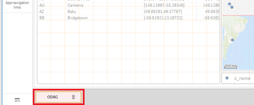
I tried the sample app in QSE, but the ODAG button is displayed as invalid visualization. Do I need any additional extensions or whatever?
- Mark as New
- Bookmark
- Subscribe
- Mute
- Subscribe to RSS Feed
- Permalink
- Report Inappropriate Content
Hi, yes you need to recreate the odag link when copying to a new environment.
And odag needs to be enabled.
Read more aobut odag here:
Thanks,
Patric
- Mark as New
- Bookmark
- Subscribe
- Mute
- Subscribe to RSS Feed
- Permalink
- Report Inappropriate Content
@Patric_Nordstromis there any way to find out the possible criteria values of GeoAnalytics location service?
For example, in Routing Danish Cities app the routes are built using the following parameters: criteria='fastest', transportation='car'. Just by chance I guessed, that criteria could also be 'shortest' and it really worked. But I have no idea what are the other (if exist) options for transportation type. I tried different stuff like 'walk', 'plane', 'train', but none worked.
This page https://help.qlik.com/en-US/geoanalytics/Content/Qlik_GeoAnalytics/GeoAnalytics-Sense/Location-Servi... doesn't mention such parameters at all. It is more about addresses and administrative divisions.
Thanks.
- Mark as New
- Bookmark
- Subscribe
- Mute
- Subscribe to RSS Feed
- Permalink
- Report Inappropriate Content
The "Routes" operation is documented under the QGA Connector section:
Thanks,
Patric
- « Previous Replies
-
- 1
- 2
- Next Replies »
