Unlock a world of possibilities! Login now and discover the exclusive benefits awaiting you.
- Qlik Community
- :
- All Forums
- :
- GeoAnalytics
- :
- Re: Is there any limitation for geoanalytics not p...
- Subscribe to RSS Feed
- Mark Topic as New
- Mark Topic as Read
- Float this Topic for Current User
- Bookmark
- Subscribe
- Mute
- Printer Friendly Page
- Mark as New
- Bookmark
- Subscribe
- Mute
- Subscribe to RSS Feed
- Permalink
- Report Inappropriate Content
Is there any limitation for geoanalytics not possible to be changed in no. of Arealayer objects ?
Hi ,
Does anyone know the definition of Max no. of objects in Arealayer objects for geoanalytics ?
Is it how many polygons, lines , and points can be displayed on the map ? If so , the max is only 1000 polygons+lines+points?
Is it possible we can change the Max no. of objects with out crash qlikview to any numbers above 1000 default since qlikview just crashes for me if I set up higher numbers (2000, 4000 etc...) than 1000?
Thanks ,
Wallace
Accepted Solutions
- Mark as New
- Bookmark
- Subscribe
- Mute
- Subscribe to RSS Feed
- Permalink
- Report Inappropriate Content
Hi Wallace,
The limit is the number of the objects in the layer for the Bubble layer : number of bubbles, Area layer : number of areas, Line layer : number of lines and so fourth.
For area layers it is possible to overload Qlikview if the number of breakpoints per area is too large, like one area with one million breakpoints. In order to get good performance of a web application it's recommended to bring down the number of breakpoints, the resolution of the areas. Adjusting resolution also helps the user to distinguish what's important. This can be done with the Simplify operation in the QGA connector. Building drill down hierarchies is also a good approach, switching between resolution depending on the number of objects is another.
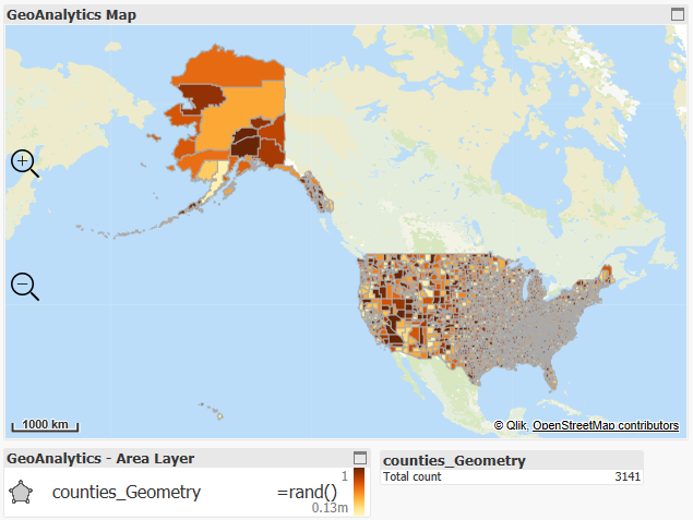
Here's an example with geometries for the US counties, more than 3000 area in on layer, so there is no fix limit of 1000 objects. The individual areas are hard to see, a drill down with states probably would have been better.
Thanks,
Patric
- Mark as New
- Bookmark
- Subscribe
- Mute
- Subscribe to RSS Feed
- Permalink
- Report Inappropriate Content
Hi Wallace,
The limit is the number of the objects in the layer for the Bubble layer : number of bubbles, Area layer : number of areas, Line layer : number of lines and so fourth.
For area layers it is possible to overload Qlikview if the number of breakpoints per area is too large, like one area with one million breakpoints. In order to get good performance of a web application it's recommended to bring down the number of breakpoints, the resolution of the areas. Adjusting resolution also helps the user to distinguish what's important. This can be done with the Simplify operation in the QGA connector. Building drill down hierarchies is also a good approach, switching between resolution depending on the number of objects is another.
Here's an example with geometries for the US counties, more than 3000 area in on layer, so there is no fix limit of 1000 objects. The individual areas are hard to see, a drill down with states probably would have been better.
Thanks,
Patric
- Mark as New
- Bookmark
- Subscribe
- Mute
- Subscribe to RSS Feed
- Permalink
- Report Inappropriate Content
Hi Patric,
The setting of max objects for area layers look working fine now but it pops up an errors message as follows. May I ask what it means since the areas polygons featured adding fine in the map and how to fix it ? 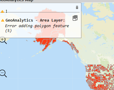
Thanks ,
Wallace
- Mark as New
- Bookmark
- Subscribe
- Mute
- Subscribe to RSS Feed
- Permalink
- Report Inappropriate Content
Hi,
Change the log level: Map settings->Appearance->Interaction and Controls->Log level: Debug
Then the map will tell more details about the errors.
Thanks,
Patric