Unlock a world of possibilities! Login now and discover the exclusive benefits awaiting you.
- Qlik Community
- :
- Forums
- :
- Forums by Product
- :
- Products (A-Z)
- :
- Qlik Sense
- :
- Documents
- :
- Setting up a TMS as a background map in Qlik GeoAn...
- Move Document
- Delete Document
- Subscribe to RSS Feed
- Mark as New
- Mark as Read
- Bookmark
- Subscribe
- Printer Friendly Page
- Report Inappropriate Content
Setting up a TMS as a background map in Qlik GeoAnalytics
- Move Document
- Delete Document and Replies
- Mark as New
- Bookmark
- Subscribe
- Mute
- Subscribe to RSS Feed
- Permalink
- Report Inappropriate Content
Setting up a TMS as a background map in Qlik GeoAnalytics
Apr 2, 2021 4:15:50 AM
May 12, 2017 2:45:59 AM
QGA can consume geodata from many different sources, here's what's needed to use a TMS a background map in QGA.
Sense Map chart
Start with specifying the source. In this case the source is a TMS from ArcGIS Online: World_Topo_Map.
- The TMS service is specified as a url with parameters for X, Y as Z, which specifies the position of the map image and the scale level. At ArcGIS Online the start tile is defined as: https://services.arcgisonline.com/arcgis/rest/services/World_Topo_Map/MapServer/tile/0/0/0 with z, y... as the order of the last parameters.
- Exchange the last part of the parameters and format as a string, this is the Tile Service URL:
='http://server.arcgisonline.com/arcgis/rest/services/World_Topo_Map/MapServer/tile/${z}/${y}/${x}' - Create a map and add a Background layer
- For the Background layer specify the URL.
- Don't forget to include the copyright text in the attribution:
Sources: Esri, HERE, DeLorme, Intermap, increment P Corp., GEBCO, USGS, FAO, NPS, NRCAN, GeoBase, IGN, Kadaster NL, Ordnance Survey, Esri Japan, METI, Esri China (Hong Kong), swisstopo, MapmyIndia, © OpenStreetMap contributors, and the GIS User Community
Old QGA Map extensions
Start with specifying the source. In this case the source is a TMS from ArcGIS Online: World_Topo_Map.
- The TMS service is specified as a url with parameters for X, Y as Z, which specifies the position of the map image and the scale level. At ArcGIS Online the start tile is defined as: https://services.arcgisonline.com/arcgis/rest/services/World_Topo_Map/MapServer/tile/0/0/0 with z, y... as the order of the last parameters.
- Exchange the last part of the parameters and format as a string, this is the Tile Service URL:
='http://server.arcgisonline.com/arcgis/rest/services/World_Topo_Map/MapServer/tile/{z}/{y}/{x}' - Create a map view and a geodata layer
- For the geodata layer specify the Tile Service URL and Source format: TMS and Tile Size: 256.
- Don't forget to include the copyright text some where in the app, in this case the attribution should be:
Sources: Esri, HERE, DeLorme, Intermap, increment P Corp., GEBCO, USGS, FAO, NPS, NRCAN, GeoBase, IGN, Kadaster NL, Ordnance Survey, Esri Japan, METI, Esri China (Hong Kong), swisstopo, MapmyIndia, © OpenStreetMap contributors, and the GIS User Community
See also the two attachments, example apps for Qlik Sense and QlikView.¨
Authentication in ArcGIS
Special note regarding Authentication in ArcGIS (Thanks to ssamuels for the solution)
The authentication when working with secured map services from ESRI can be solved by setting up a REST connection in the loadscript to retrieve a new access token from the REST API of ArcGIS Online. This is done by sending a GenerateToken request to the URL "https://www.arcgis.com/sharing/generateToken?parameters". The REST call must be a POST request over https and takes the following parameters:
username - Username of the user who wishes to get a token.
password - Password of user who wishes to get a token.
referer - The base URL of the web application that will invoke the services
expiration - The token expiration time in minutes (default value for this parameter is 60 minutes)
f - The response format. The value for this parameter must be "json".
The resulting access token is stored in the data model and can be used as a text variable to append to the location service url in the GeoAnalytics extension.
- Move Comment
- Delete Comment
- Mark as Read
- Mark as New
- Bookmark
- Permalink
- Report Inappropriate Content
Is it possible to define this as a "default" background map on a local Geoanalytics Server ?
- Move Comment
- Delete Comment
- Mark as Read
- Mark as New
- Bookmark
- Permalink
- Report Inappropriate Content
Hi,
Sorry no, the default base map for the map view is the Qlik provided base map.
I suggest creating a template app, like suggested by Göran Sander:
https://branch-blog.qlik.com/skeleton-apps-in-qlik-sense-5d20b187fbe2
Thanks,
Patric
- Move Comment
- Delete Comment
- Mark as Read
- Mark as New
- Bookmark
- Permalink
- Report Inappropriate Content
Hi Patrick,
I have a Tile service link which is a secured service . Something like below
This is a proxy service and using this link and appending /tile/{x}/{y}/{z} is not helping to load the map.
I have asked the GIS Team to provide a token based link. They will provide me a token. How to inculcate that token into the link.
Not sure how clearly I could explain but any pointers would help
- Move Comment
- Delete Comment
- Mark as Read
- Mark as New
- Bookmark
- Permalink
- Report Inappropriate Content
Hi Rajan,
See above, I added a section about token based authentication.
Thanks,
Patric
- Move Comment
- Delete Comment
- Mark as Read
- Mark as New
- Bookmark
- Permalink
- Report Inappropriate Content
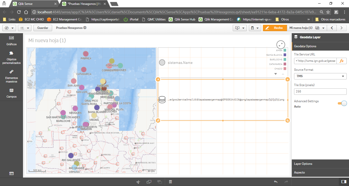
Hi Patric, I'm trying to setup TMS against a local public server but somehow tiles come up in the wrong order, any idea what could be wrong?
TMS URL is http://wms.ign.gob.ar/geoserver/gwc/service/tms/1.0.0/capabaseargenmap@EPSG%3A4326@png/capabaseargen...{z}/{y}/{x}.png
Thanks a lot for your help.
- Move Comment
- Delete Comment
- Mark as Read
- Mark as New
- Bookmark
- Permalink
- Report Inappropriate Content
Hi,
This because the TMS is non-standard, is using CRS84, so the y axis is upside down.
We hope be able to support that in coming versions.
Thanks,
Patric
- Move Comment
- Delete Comment
- Mark as Read
- Mark as New
- Bookmark
- Permalink
- Report Inappropriate Content
Ok, thanks for your reply Patric. I'll keep an eye on the release notes then.
- Move Comment
- Delete Comment
- Mark as Read
- Mark as New
- Bookmark
- Permalink
- Report Inappropriate Content
Hi Patric ,
It looks Tile map service is all earth map for geoanalytics to consume? Is it possible we can create a specific area from UAV image for tile map service for geoaanalytics to consume? and put this specific area UAV image tile map service via Geoanalytics Geodata layer on top of earth basemap from GeoAnalytics sMap in geoanalytics ?
Thanks
- Move Comment
- Delete Comment
- Mark as Read
- Mark as New
- Bookmark
- Permalink
- Report Inappropriate Content
Hi Wallace,
QGA will use whatever the TMS produce, so also TMS with subset bounds, less than the whole earth can be used. The default is to autozoom to the selection, currently there is no pan and zoom limits for the whole map.
Thanks,
Patric
- Move Comment
- Delete Comment
- Mark as Read
- Mark as New
- Bookmark
- Permalink
- Report Inappropriate Content
Hello Patric,
Currently we are working with a client to explore and evaluate the functionality of Qlik Geo Analytics Enterprise with ArcGIS for there environment and the decision of going ahead depends on integration of ArcGIS Map in Qlik Geo Analytics. So far we have successfully fetched the data from ArcGIS of area, bubble and line layers. Now we want to overlay the ArcGIS map on default openstreet map of Geo Analytics.
We are not ArcGIS experts so want your valuable opinion that our clients ArcGIS team says that:
- Qlikview geo-analytics does not support ArcGIS standardized tile map service
Qlikview Format: http://server.arcgisonline.com/arcgis/rest/services/'&Basemap_str&'/MapServer/tile/{z}/{y}/{x}
where as it should be:
Standardized Format: http://server.arcgisonline.com/arcgis/rest/services/World_Imagery/MapServer?f=jsapi
Any help in this regards would be appreciated.
Thanks and Regards,
Hassam.